You are here: Home > Network List > TA - USArray Transportable Network (new EarthScope stations) Stations List
> Station 339A Huntington, TX, USA > Earthquake Result Viewer
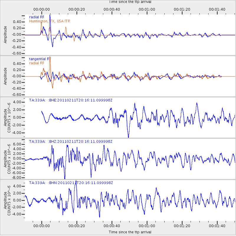
339A Huntington, TX, USA - Earthquake Result Viewer
*The percent match for this event was below the threshold and hence no stack was calculated.
| Earthquake location: |
Near Coast Of Central Chile |
| Earthquake latitude/longitude: |
-36.5/-73.1 |
| Earthquake time(UTC): |
2011/02/11 (042) 20:05:30 GMT |
| Earthquake Depth: |
28 km |
| Earthquake Magnitude: |
6.0 MB, 6.8 MW, 6.8 MW |
| Earthquake Catalog/Contributor: |
WHDF/NEIC |
|
| Network: |
TA USArray Transportable Network (new EarthScope stations) |
| Station: |
339A Huntington, TX, USA |
| Lat/Lon: |
31.33 N/94.56 W |
| Elevation: |
82 m |
|
| Distance: |
70.4 deg |
| Az: |
340.614 deg |
| Baz: |
161.781 deg |
| Ray Param: |
$rayparam |
*The percent match for this event was below the threshold and hence was not used in the summary stack. |
|
| Radial Match: |
85.449326 % |
| Radial Bump: |
383 |
| Transverse Match: |
47.368526 % |
| Transverse Bump: |
380 |
| SOD ConfigId: |
350818 |
| Insert Time: |
2011-07-22 09:34:31.945 +0000 |
| GWidth: |
2.5 |
| Max Bumps: |
400 |
| Tol: |
0.001 |
|
Signal To Noise
| Channel | StoN | STA | LTA |
| TA:339A: :BHZ:20110211T20:16:11.099998Z | 1.8793008 | 8.870252E-7 | 4.7199742E-7 |
| TA:339A: :BHN:20110211T20:16:11.099998Z | 0.6274199 | 4.890129E-7 | 7.794029E-7 |
| TA:339A: :BHE:20110211T20:16:11.099998Z | 0.68505436 | 4.0332333E-7 | 5.8874645E-7 |
| Arrivals |
| Ps | |
| PpPs | |
| PsPs/PpSs | |


