You are here: Home > Network List > TA - USArray Transportable Network (new EarthScope stations) Stations List
> Station Y38A Idabel, OK, USA > Earthquake Result Viewer
Y38A Idabel, OK, USA - Earthquake Result Viewer
| Earthquake location: |
Near Coast Of Central Chile |
| Earthquake latitude/longitude: |
-36.5/-73.1 |
| Earthquake time(UTC): |
2011/02/11 (042) 20:05:30 GMT |
| Earthquake Depth: |
28 km |
| Earthquake Magnitude: |
6.0 MB, 6.8 MW, 6.8 MW |
| Earthquake Catalog/Contributor: |
WHDF/NEIC |
|
| Network: |
TA USArray Transportable Network (new EarthScope stations) |
| Station: |
Y38A Idabel, OK, USA |
| Lat/Lon: |
33.93 N/94.73 W |
| Elevation: |
118 m |
|
| Distance: |
72.9 deg |
| Az: |
341.316 deg |
| Baz: |
161.908 deg |
| Ray Param: |
0.053330492 |
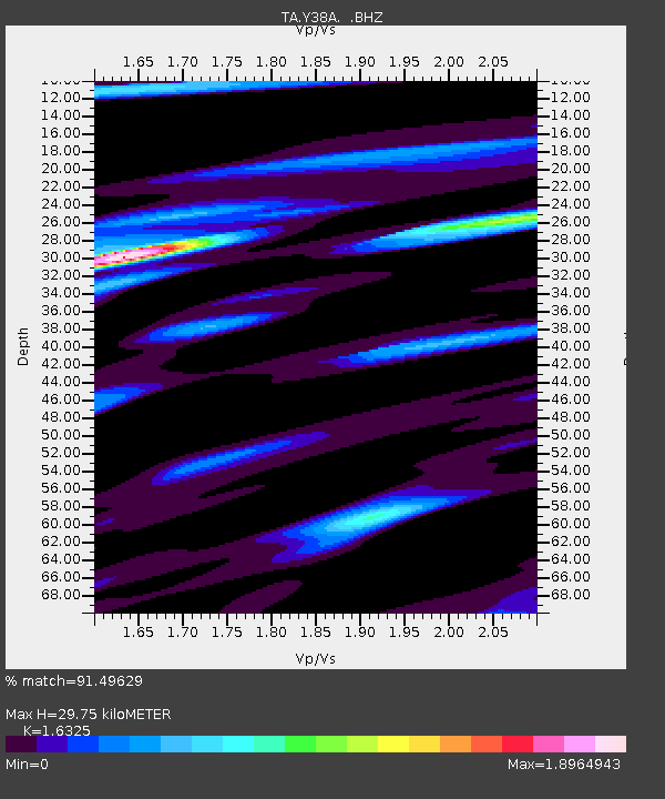
| Estimated Moho Depth: |
29.75 km |
| Estimated Crust Vp/Vs: |
1.63 |
| Assumed Crust Vp: |
6.245 km/s |
| Estimated Crust Vs: |
3.826 km/s |
| Estimated Crust Poisson's Ratio: |
0.20 |
|
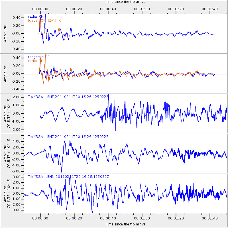
| Radial Match: |
91.49629 % |
| Radial Bump: |
400 |
| Transverse Match: |
63.809067 % |
| Transverse Bump: |
400 |
| SOD ConfigId: |
350818 |
| Insert Time: |
2011-07-22 09:41:51.040 +0000 |
| GWidth: |
2.5 |
| Max Bumps: |
400 |
| Tol: |
0.001 |
|
Signal To Noise
| Channel | StoN | STA | LTA |
| TA:Y38A: :BHZ:20110211T20:16:26.125022Z | 3.5360954 | 8.3901364E-7 | 2.3727122E-7 |
| TA:Y38A: :BHN:20110211T20:16:26.125022Z | 1.8478638 | 3.9335896E-7 | 2.1287227E-7 |
| TA:Y38A: :BHE:20110211T20:16:26.125022Z | 0.40919253 | 1.8035894E-7 | 4.407679E-7 |
| Arrivals |
| Ps | 3.1 SECOND |
| PpPs | 12 SECOND |
| PsPs/PpSs | 15 SECOND |


