You are here: Home > Network List > AZ - ANZA Regional Network Stations List
> Station SMER AZ.SMER > Earthquake Result Viewer
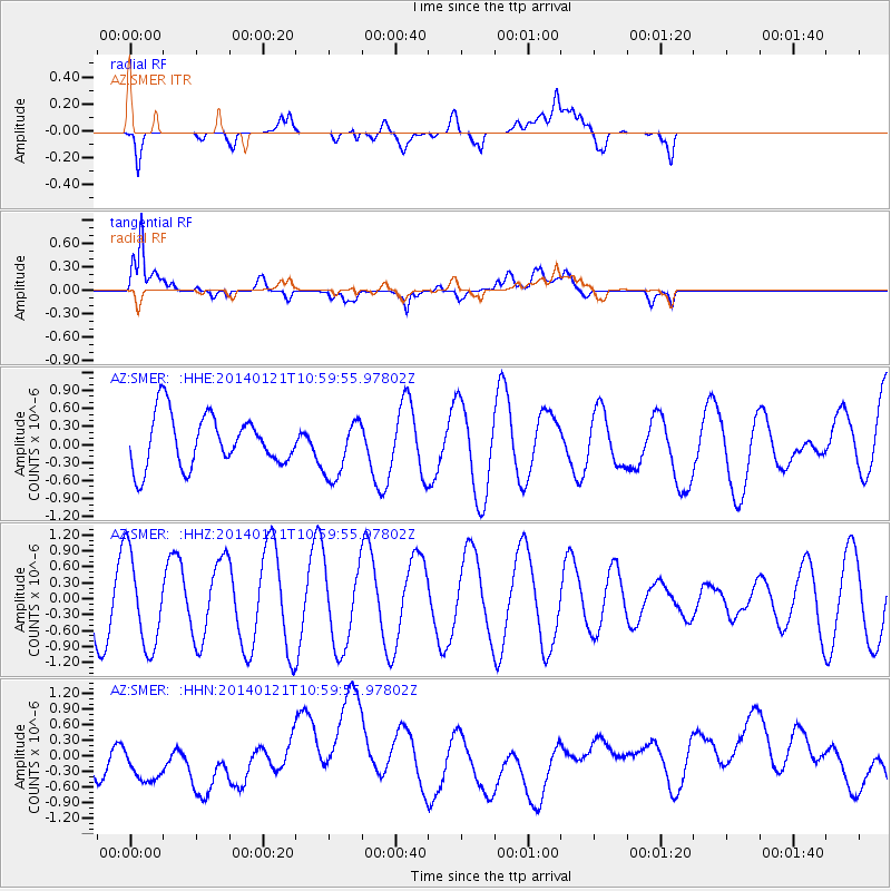
SMER AZ.SMER - Earthquake Result Viewer
*The percent match for this event was below the threshold and hence no stack was calculated.
| Earthquake location: |
Kuril Islands |
| Earthquake latitude/longitude: |
49.1/156.3 |
| Earthquake time(UTC): |
2014/01/21 (021) 10:50:00 GMT |
| Earthquake Depth: |
34 km |
| Earthquake Magnitude: |
5.5 MW |
| Earthquake Catalog/Contributor: |
ISC/ISC |
|
| Network: |
AZ ANZA Regional Network |
| Station: |
SMER AZ.SMER |
| Lat/Lon: |
33.46 N/117.17 W |
| Elevation: |
355 m |
|
| Distance: |
63.5 deg |
| Az: |
68.833 deg |
| Baz: |
312.802 deg |
| Ray Param: |
$rayparam |
*The percent match for this event was below the threshold and hence was not used in the summary stack. |
|
| Radial Match: |
39.65132 % |
| Radial Bump: |
400 |
| Transverse Match: |
68.25075 % |
| Transverse Bump: |
400 |
| SOD ConfigId: |
3390531 |
| Insert Time: |
2019-04-10 01:45:36.536 +0000 |
| GWidth: |
2.5 |
| Max Bumps: |
400 |
| Tol: |
0.001 |
|
Signal To Noise
| Channel | StoN | STA | LTA |
| AZ:SMER: :HHZ:20140121T10:59:55.97802Z | 1.5040332 | 8.7653336E-7 | 5.827886E-7 |
| AZ:SMER: :HHN:20140121T10:59:55.97802Z | 0.6218725 | 3.551577E-7 | 5.7111015E-7 |
| AZ:SMER: :HHE:20140121T10:59:55.97802Z | 1.1325754 | 4.840602E-7 | 4.273978E-7 |
| Arrivals |
| Ps | |
| PpPs | |
| PsPs/PpSs | |


