You are here: Home > Network List > TA - USArray Transportable Network (new EarthScope stations) Stations List
> Station S37A Fort Scott, KS, USA > Earthquake Result Viewer
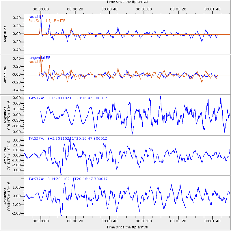
S37A Fort Scott, KS, USA - Earthquake Result Viewer
*The percent match for this event was below the threshold and hence no stack was calculated.
| Earthquake location: |
Near Coast Of Central Chile |
| Earthquake latitude/longitude: |
-36.5/-73.1 |
| Earthquake time(UTC): |
2011/02/11 (042) 20:05:30 GMT |
| Earthquake Depth: |
28 km |
| Earthquake Magnitude: |
6.0 MB, 6.8 MW, 6.8 MW |
| Earthquake Catalog/Contributor: |
WHDF/NEIC |
|
| Network: |
TA USArray Transportable Network (new EarthScope stations) |
| Station: |
S37A Fort Scott, KS, USA |
| Lat/Lon: |
37.76 N/94.83 W |
| Elevation: |
260 m |
|
| Distance: |
76.5 deg |
| Az: |
342.461 deg |
| Baz: |
162.153 deg |
| Ray Param: |
$rayparam |
*The percent match for this event was below the threshold and hence was not used in the summary stack. |
|
| Radial Match: |
77.07351 % |
| Radial Bump: |
366 |
| Transverse Match: |
63.039158 % |
| Transverse Bump: |
400 |
| SOD ConfigId: |
350818 |
| Insert Time: |
2011-07-22 09:52:33.427 +0000 |
| GWidth: |
2.5 |
| Max Bumps: |
400 |
| Tol: |
0.001 |
|
Signal To Noise
| Channel | StoN | STA | LTA |
| TA:S37A: :BHZ:20110211T20:16:47.30001Z | 2.6930194 | 8.0978253E-7 | 3.0069685E-7 |
| TA:S37A: :BHN:20110211T20:16:47.30001Z | 1.6398424 | 4.4765247E-7 | 2.7298506E-7 |
| TA:S37A: :BHE:20110211T20:16:47.30001Z | 1.5504618 | 4.0675573E-7 | 2.623449E-7 |
| Arrivals |
| Ps | |
| PpPs | |
| PsPs/PpSs | |


