You are here: Home > Network List > TA - USArray Transportable Network (new EarthScope stations) Stations List
> Station J31A Geddes, SD, USA > Earthquake Result Viewer
J31A Geddes, SD, USA - Earthquake Result Viewer
| Earthquake location: |
Near Coast Of Central Chile |
| Earthquake latitude/longitude: |
-36.5/-73.1 |
| Earthquake time(UTC): |
2011/02/11 (042) 20:05:30 GMT |
| Earthquake Depth: |
28 km |
| Earthquake Magnitude: |
6.0 MB, 6.8 MW, 6.8 MW |
| Earthquake Catalog/Contributor: |
WHDF/NEIC |
|
| Network: |
TA USArray Transportable Network (new EarthScope stations) |
| Station: |
J31A Geddes, SD, USA |
| Lat/Lon: |
43.29 N/98.74 W |
| Elevation: |
491 m |
|
| Distance: |
82.7 deg |
| Az: |
341.445 deg |
| Baz: |
159.435 deg |
| Ray Param: |
0.046641275 |
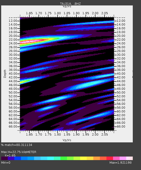
| Estimated Moho Depth: |
22.75 km |
| Estimated Crust Vp/Vs: |
1.65 |
| Assumed Crust Vp: |
6.53 km/s |
| Estimated Crust Vs: |
3.958 km/s |
| Estimated Crust Poisson's Ratio: |
0.21 |
|
| Radial Match: |
80.311134 % |
| Radial Bump: |
400 |
| Transverse Match: |
70.46807 % |
| Transverse Bump: |
400 |
| SOD ConfigId: |
350818 |
| Insert Time: |
2011-07-22 09:56:28.039 +0000 |
| GWidth: |
2.5 |
| Max Bumps: |
400 |
| Tol: |
0.001 |
|
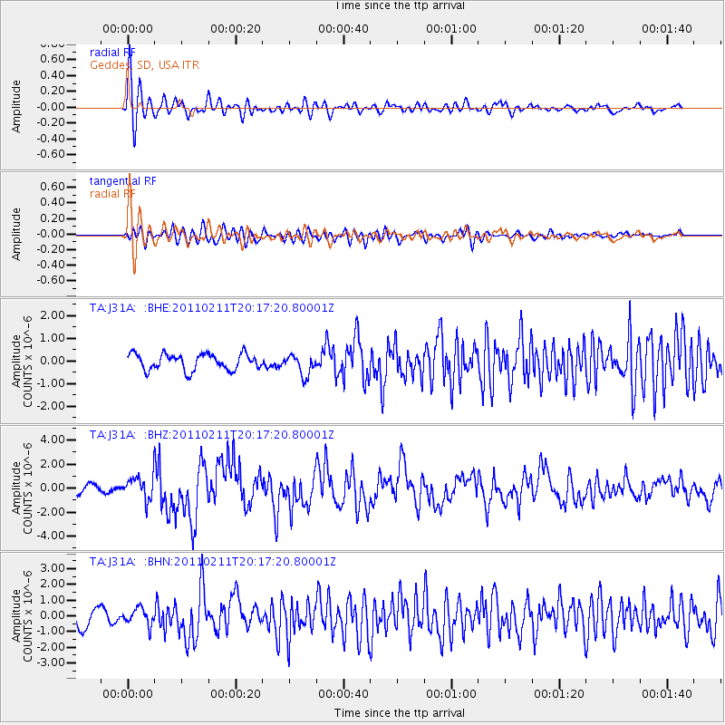
Signal To Noise
| Channel | StoN | STA | LTA |
| TA:J31A: :BHZ:20110211T20:17:20.80001Z | 3.1877022 | 9.958075E-7 | 3.1239034E-7 |
| TA:J31A: :BHN:20110211T20:17:20.80001Z | 1.0383873 | 5.343692E-7 | 5.146145E-7 |
| TA:J31A: :BHE:20110211T20:17:20.80001Z | 1.3064432 | 4.6272706E-7 | 3.5418844E-7 |
| Arrivals |
| Ps | 2.3 SECOND |
| PpPs | 9.0 SECOND |
| PsPs/PpSs | 11 SECOND |


