You are here: Home > Network List > TA - USArray Transportable Network (new EarthScope stations) Stations List
> Station G35A Watkins, MN, USA > Earthquake Result Viewer
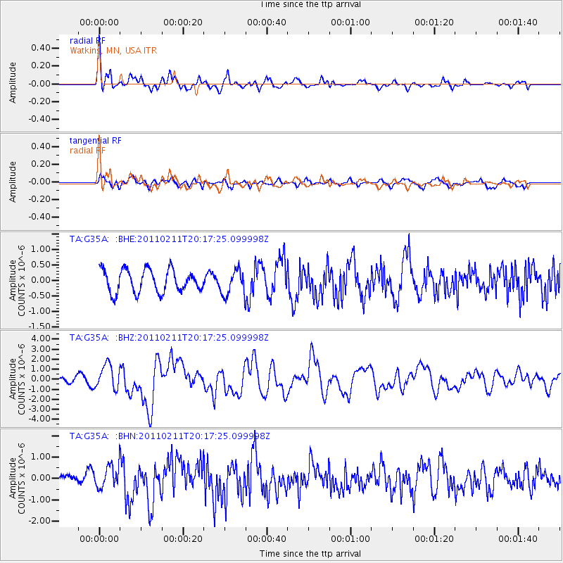
G35A Watkins, MN, USA - Earthquake Result Viewer
*The percent match for this event was below the threshold and hence no stack was calculated.
| Earthquake location: |
Near Coast Of Central Chile |
| Earthquake latitude/longitude: |
-36.5/-73.1 |
| Earthquake time(UTC): |
2011/02/11 (042) 20:05:30 GMT |
| Earthquake Depth: |
28 km |
| Earthquake Magnitude: |
6.0 MB, 6.8 MW, 6.8 MW |
| Earthquake Catalog/Contributor: |
WHDF/NEIC |
|
| Network: |
TA USArray Transportable Network (new EarthScope stations) |
| Station: |
G35A Watkins, MN, USA |
| Lat/Lon: |
45.22 N/94.49 W |
| Elevation: |
361 m |
|
| Distance: |
83.6 deg |
| Az: |
344.986 deg |
| Baz: |
162.816 deg |
| Ray Param: |
$rayparam |
*The percent match for this event was below the threshold and hence was not used in the summary stack. |
|
| Radial Match: |
73.82666 % |
| Radial Bump: |
400 |
| Transverse Match: |
48.111755 % |
| Transverse Bump: |
400 |
| SOD ConfigId: |
350818 |
| Insert Time: |
2011-07-22 10:03:42.384 +0000 |
| GWidth: |
2.5 |
| Max Bumps: |
400 |
| Tol: |
0.001 |
|
Signal To Noise
| Channel | StoN | STA | LTA |
| TA:G35A: :BHZ:20110211T20:17:25.099998Z | 2.9580252 | 1.237817E-6 | 4.1846062E-7 |
| TA:G35A: :BHN:20110211T20:17:25.099998Z | 1.7183625 | 5.561368E-7 | 3.236435E-7 |
| TA:G35A: :BHE:20110211T20:17:25.099998Z | 1.1527165 | 4.196343E-7 | 3.6403947E-7 |
| Arrivals |
| Ps | |
| PpPs | |
| PsPs/PpSs | |


