You are here: Home > Network List > II - Global Seismograph Network (GSN - IRIS/IDA) Stations List
> Station TAU Hobart, Tasmania, Australia > Earthquake Result Viewer
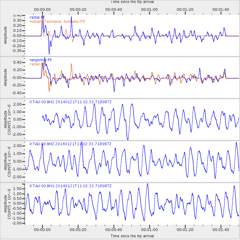
TAU Hobart, Tasmania, Australia - Earthquake Result Viewer
*The percent match for this event was below the threshold and hence no stack was calculated.
| Earthquake location: |
Kuril Islands |
| Earthquake latitude/longitude: |
49.1/156.3 |
| Earthquake time(UTC): |
2014/01/21 (021) 10:50:00 GMT |
| Earthquake Depth: |
34 km |
| Earthquake Magnitude: |
5.5 MW |
| Earthquake Catalog/Contributor: |
ISC/ISC |
|
| Network: |
II Global Seismograph Network (GSN - IRIS/IDA) |
| Station: |
TAU Hobart, Tasmania, Australia |
| Lat/Lon: |
42.91 S/147.32 E |
| Elevation: |
132 m |
|
| Distance: |
91.9 deg |
| Az: |
186.568 deg |
| Baz: |
5.877 deg |
| Ray Param: |
$rayparam |
*The percent match for this event was below the threshold and hence was not used in the summary stack. |
|
| Radial Match: |
61.459118 % |
| Radial Bump: |
390 |
| Transverse Match: |
48.81377 % |
| Transverse Bump: |
400 |
| SOD ConfigId: |
3390531 |
| Insert Time: |
2019-04-10 01:47:23.297 +0000 |
| GWidth: |
2.5 |
| Max Bumps: |
400 |
| Tol: |
0.001 |
|
Signal To Noise
| Channel | StoN | STA | LTA |
| II:TAU:00:BHZ:20140121T11:02:33.718987Z | 1.7556108 | 1.1487479E-6 | 6.543294E-7 |
| II:TAU:00:BH1:20140121T11:02:33.718987Z | 0.56413054 | 3.6760477E-7 | 6.516307E-7 |
| II:TAU:00:BH2:20140121T11:02:33.718987Z | 2.0404327 | 1.3109648E-6 | 6.4249355E-7 |
| Arrivals |
| Ps | |
| PpPs | |
| PsPs/PpSs | |


