You are here: Home > Network List > TA - USArray Transportable Network (new EarthScope stations) Stations List
> Station P38A Dawn, MO, USA > Earthquake Result Viewer
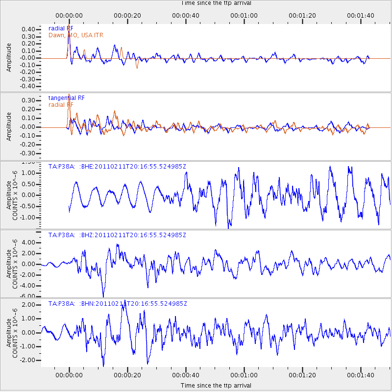
P38A Dawn, MO, USA - Earthquake Result Viewer
*The percent match for this event was below the threshold and hence no stack was calculated.
| Earthquake location: |
Near Coast Of Central Chile |
| Earthquake latitude/longitude: |
-36.5/-73.1 |
| Earthquake time(UTC): |
2011/02/11 (042) 20:05:30 GMT |
| Earthquake Depth: |
28 km |
| Earthquake Magnitude: |
6.0 MB, 6.8 MW, 6.8 MW |
| Earthquake Catalog/Contributor: |
WHDF/NEIC |
|
| Network: |
TA USArray Transportable Network (new EarthScope stations) |
| Station: |
P38A Dawn, MO, USA |
| Lat/Lon: |
39.62 N/93.53 W |
| Elevation: |
248 m |
|
| Distance: |
78.0 deg |
| Az: |
344.02 deg |
| Baz: |
163.303 deg |
| Ray Param: |
$rayparam |
*The percent match for this event was below the threshold and hence was not used in the summary stack. |
|
| Radial Match: |
58.666626 % |
| Radial Bump: |
400 |
| Transverse Match: |
43.23635 % |
| Transverse Bump: |
400 |
| SOD ConfigId: |
350818 |
| Insert Time: |
2011-07-22 10:14:03.424 +0000 |
| GWidth: |
2.5 |
| Max Bumps: |
400 |
| Tol: |
0.001 |
|
Signal To Noise
| Channel | StoN | STA | LTA |
| TA:P38A: :BHZ:20110211T20:16:55.524985Z | 4.198371 | 9.757763E-7 | 2.3241783E-7 |
| TA:P38A: :BHN:20110211T20:16:55.524985Z | 0.94566625 | 4.1622334E-7 | 4.4013768E-7 |
| TA:P38A: :BHE:20110211T20:16:55.524985Z | 0.6556773 | 2.277285E-7 | 3.4731795E-7 |
| Arrivals |
| Ps | |
| PpPs | |
| PsPs/PpSs | |


