You are here: Home > Network List > TA - USArray Transportable Network (new EarthScope stations) Stations List
> Station Q40A Laux Farm, Auxvasse, MO, USA > Earthquake Result Viewer
Q40A Laux Farm, Auxvasse, MO, USA - Earthquake Result Viewer
| Earthquake location: |
Near Coast Of Central Chile |
| Earthquake latitude/longitude: |
-36.5/-73.1 |
| Earthquake time(UTC): |
2011/02/11 (042) 20:05:30 GMT |
| Earthquake Depth: |
28 km |
| Earthquake Magnitude: |
6.0 MB, 6.8 MW, 6.8 MW |
| Earthquake Catalog/Contributor: |
WHDF/NEIC |
|
| Network: |
TA USArray Transportable Network (new EarthScope stations) |
| Station: |
Q40A Laux Farm, Auxvasse, MO, USA |
| Lat/Lon: |
38.99 N/92.07 W |
| Elevation: |
275 m |
|
| Distance: |
77.1 deg |
| Az: |
344.953 deg |
| Baz: |
164.424 deg |
| Ray Param: |
0.05051203 |
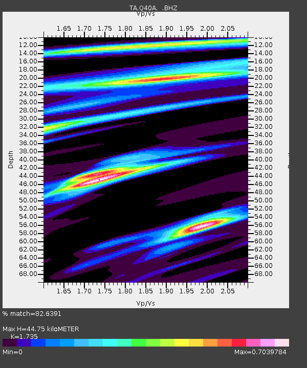
| Estimated Moho Depth: |
44.75 km |
| Estimated Crust Vp/Vs: |
1.74 |
| Assumed Crust Vp: |
6.498 km/s |
| Estimated Crust Vs: |
3.745 km/s |
| Estimated Crust Poisson's Ratio: |
0.25 |
|
| Radial Match: |
82.6391 % |
| Radial Bump: |
287 |
| Transverse Match: |
74.282684 % |
| Transverse Bump: |
400 |
| SOD ConfigId: |
350818 |
| Insert Time: |
2011-07-22 10:15:02.441 +0000 |
| GWidth: |
2.5 |
| Max Bumps: |
400 |
| Tol: |
0.001 |
|

Signal To Noise
| Channel | StoN | STA | LTA |
| TA:Q40A: :BHZ:20110211T20:16:50.42501Z | 4.0180063 | 1.2025945E-6 | 2.9930132E-7 |
| TA:Q40A: :BHN:20110211T20:16:50.42501Z | 2.3183296 | 6.000252E-7 | 2.5881792E-7 |
| TA:Q40A: :BHE:20110211T20:16:50.42501Z | 2.3161454 | 5.368256E-7 | 2.3177542E-7 |
| Arrivals |
| Ps | 5.2 SECOND |
| PpPs | 18 SECOND |
| PsPs/PpSs | 23 SECOND |


