You are here: Home > Network List > TA - USArray Transportable Network (new EarthScope stations) Stations List
> Station S38A Stockton, MO, USA > Earthquake Result Viewer
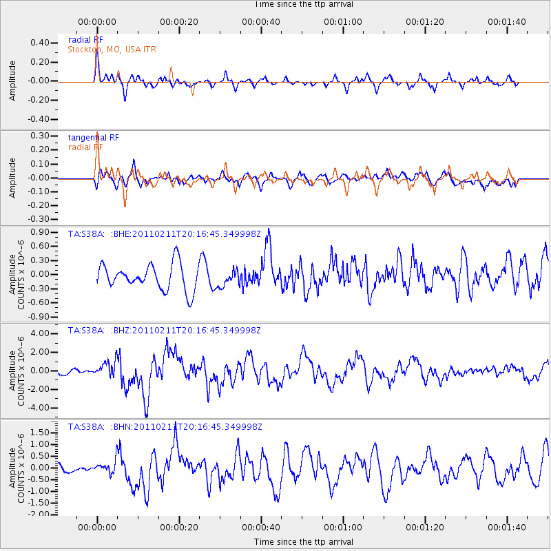
S38A Stockton, MO, USA - Earthquake Result Viewer
*The percent match for this event was below the threshold and hence no stack was calculated.
| Earthquake location: |
Near Coast Of Central Chile |
| Earthquake latitude/longitude: |
-36.5/-73.1 |
| Earthquake time(UTC): |
2011/02/11 (042) 20:05:30 GMT |
| Earthquake Depth: |
28 km |
| Earthquake Magnitude: |
6.0 MB, 6.8 MW, 6.8 MW |
| Earthquake Catalog/Contributor: |
WHDF/NEIC |
|
| Network: |
TA USArray Transportable Network (new EarthScope stations) |
| Station: |
S38A Stockton, MO, USA |
| Lat/Lon: |
37.63 N/93.91 W |
| Elevation: |
294 m |
|
| Distance: |
76.2 deg |
| Az: |
343.137 deg |
| Baz: |
162.873 deg |
| Ray Param: |
$rayparam |
*The percent match for this event was below the threshold and hence was not used in the summary stack. |
|
| Radial Match: |
79.9622 % |
| Radial Bump: |
352 |
| Transverse Match: |
65.43011 % |
| Transverse Bump: |
400 |
| SOD ConfigId: |
350818 |
| Insert Time: |
2011-07-22 10:18:06.511 +0000 |
| GWidth: |
2.5 |
| Max Bumps: |
400 |
| Tol: |
0.001 |
|
Signal To Noise
| Channel | StoN | STA | LTA |
| TA:S38A: :BHZ:20110211T20:16:45.349998Z | 2.0551906 | 8.900514E-7 | 4.3307492E-7 |
| TA:S38A: :BHN:20110211T20:16:45.349998Z | 0.8310323 | 2.9250424E-7 | 3.5197698E-7 |
| TA:S38A: :BHE:20110211T20:16:45.349998Z | 0.61372554 | 1.6786358E-7 | 2.735157E-7 |
| Arrivals |
| Ps | |
| PpPs | |
| PsPs/PpSs | |


