You are here: Home > Network List > UU - University of Utah Regional Network Stations List
> Station KNB Kanab, UT, USA > Earthquake Result Viewer
KNB Kanab, UT, USA - Earthquake Result Viewer
*The percent match for this event was below the threshold and hence no stack was calculated.
| Earthquake location: |
Kuril Islands |
| Earthquake latitude/longitude: |
49.1/156.3 |
| Earthquake time(UTC): |
2014/01/21 (021) 10:50:00 GMT |
| Earthquake Depth: |
34 km |
| Earthquake Magnitude: |
5.5 MW |
| Earthquake Catalog/Contributor: |
ISC/ISC |
|
| Network: |
UU University of Utah Regional Network |
| Station: |
KNB Kanab, UT, USA |
| Lat/Lon: |
37.02 N/112.82 W |
| Elevation: |
1715 m |
|
| Distance: |
63.7 deg |
| Az: |
63.224 deg |
| Baz: |
312.806 deg |
| Ray Param: |
$rayparam |
*The percent match for this event was below the threshold and hence was not used in the summary stack. |
|
| Radial Match: |
64.939255 % |
| Radial Bump: |
400 |
| Transverse Match: |
70.38314 % |
| Transverse Bump: |
400 |
| SOD ConfigId: |
3390531 |
| Insert Time: |
2019-04-10 01:51:29.896 +0000 |
| GWidth: |
2.5 |
| Max Bumps: |
400 |
| Tol: |
0.001 |
|
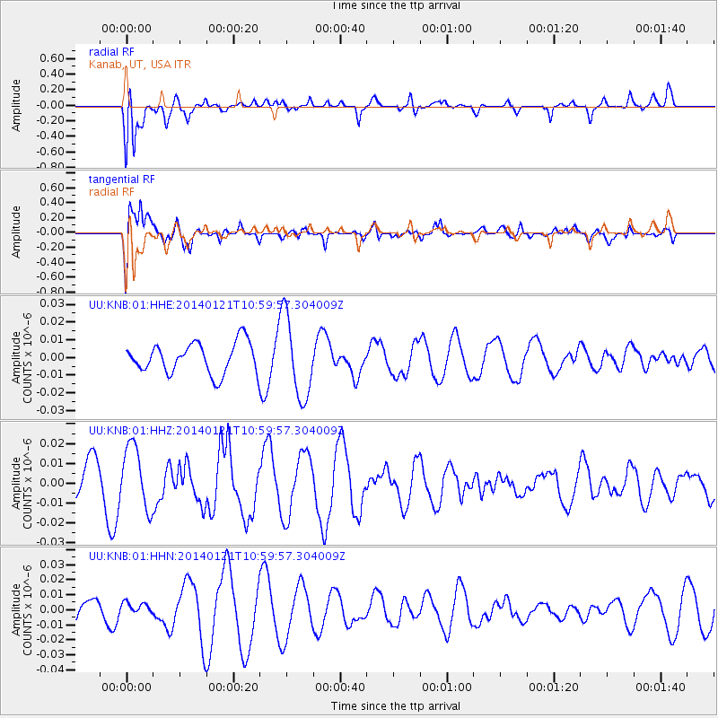
Signal To Noise
| Channel | StoN | STA | LTA |
| UU:KNB:01:HHZ:20140121T10:59:57.304009Z | 2.105615 | 1.5966068E-8 | 7.582615E-9 |
| UU:KNB:01:HHN:20140121T10:59:57.304009Z | 0.45624232 | 3.0491132E-9 | 6.6831E-9 |
| UU:KNB:01:HHE:20140121T10:59:57.304009Z | 2.673083 | 2.308929E-8 | 8.637701E-9 |
| Arrivals |
| Ps | |
| PpPs | |
| PsPs/PpSs | |


