You are here: Home > Network List > UW - Pacific Northwest Regional Seismic Network Stations List
> Station HEBO Mt. Hebo, OR CREST BB SMO > Earthquake Result Viewer
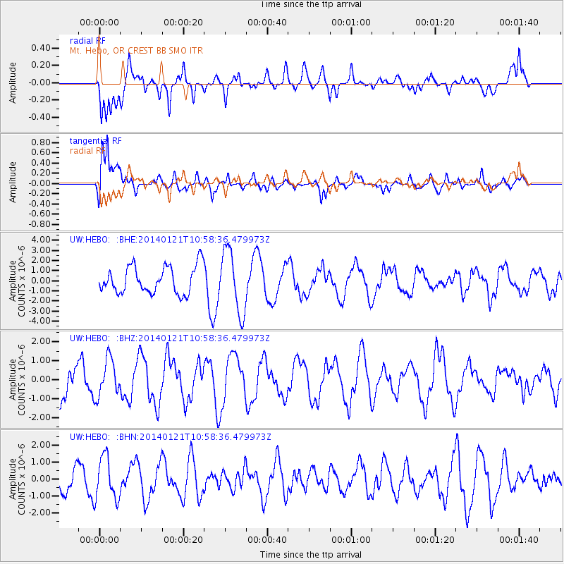
HEBO Mt. Hebo, OR CREST BB SMO - Earthquake Result Viewer
*The percent match for this event was below the threshold and hence no stack was calculated.
| Earthquake location: |
Kuril Islands |
| Earthquake latitude/longitude: |
49.1/156.3 |
| Earthquake time(UTC): |
2014/01/21 (021) 10:50:00 GMT |
| Earthquake Depth: |
34 km |
| Earthquake Magnitude: |
5.5 MW |
| Earthquake Catalog/Contributor: |
ISC/ISC |
|
| Network: |
UW Pacific Northwest Regional Seismic Network |
| Station: |
HEBO Mt. Hebo, OR CREST BB SMO |
| Lat/Lon: |
45.21 N/123.76 W |
| Elevation: |
875 m |
|
| Distance: |
52.1 deg |
| Az: |
61.842 deg |
| Baz: |
304.874 deg |
| Ray Param: |
$rayparam |
*The percent match for this event was below the threshold and hence was not used in the summary stack. |
|
| Radial Match: |
61.15599 % |
| Radial Bump: |
400 |
| Transverse Match: |
69.36497 % |
| Transverse Bump: |
400 |
| SOD ConfigId: |
3390531 |
| Insert Time: |
2019-04-10 01:51:35.924 +0000 |
| GWidth: |
2.5 |
| Max Bumps: |
400 |
| Tol: |
0.001 |
|
Signal To Noise
| Channel | StoN | STA | LTA |
| UW:HEBO: :BHZ:20140121T10:58:36.479973Z | 0.8529876 | 9.818615E-7 | 1.1510854E-6 |
| UW:HEBO: :BHN:20140121T10:58:36.479973Z | 0.9652652 | 1.2547874E-6 | 1.2999405E-6 |
| UW:HEBO: :BHE:20140121T10:58:36.479973Z | 2.3853352 | 3.174803E-6 | 1.3309673E-6 |
| Arrivals |
| Ps | |
| PpPs | |
| PsPs/PpSs | |


