You are here: Home > Network List > TA - USArray Transportable Network (new EarthScope stations) Stations List
> Station T36A Boggs Farm, Caney, KS, USA > Earthquake Result Viewer
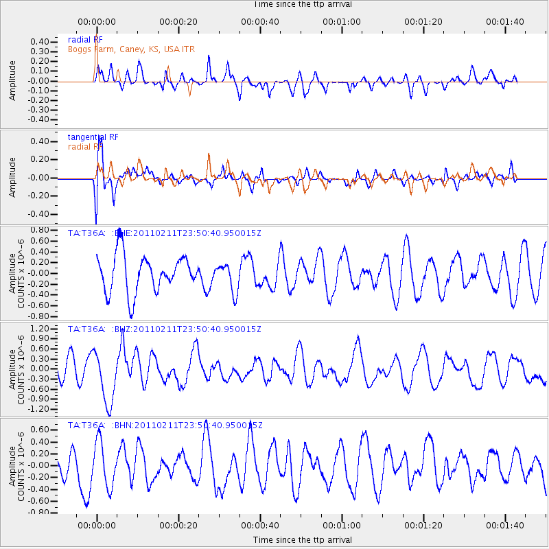
T36A Boggs Farm, Caney, KS, USA - Earthquake Result Viewer
*The percent match for this event was below the threshold and hence no stack was calculated.
| Earthquake location: |
Near Coast Of Central Chile |
| Earthquake latitude/longitude: |
-37.2/-73.2 |
| Earthquake time(UTC): |
2011/02/11 (042) 23:39:21 GMT |
| Earthquake Depth: |
15 km |
| Earthquake Magnitude: |
5.5 MB, 5.7 MS, 6.0 MW, 5.9 MW |
| Earthquake Catalog/Contributor: |
WHDF/NEIC |
|
| Network: |
TA USArray Transportable Network (new EarthScope stations) |
| Station: |
T36A Boggs Farm, Caney, KS, USA |
| Lat/Lon: |
37.06 N/95.88 W |
| Elevation: |
243 m |
|
| Distance: |
76.8 deg |
| Az: |
341.53 deg |
| Baz: |
161.564 deg |
| Ray Param: |
$rayparam |
*The percent match for this event was below the threshold and hence was not used in the summary stack. |
|
| Radial Match: |
49.947514 % |
| Radial Bump: |
400 |
| Transverse Match: |
74.22641 % |
| Transverse Bump: |
400 |
| SOD ConfigId: |
350818 |
| Insert Time: |
2011-07-22 11:38:06.205 +0000 |
| GWidth: |
2.5 |
| Max Bumps: |
400 |
| Tol: |
0.001 |
|
Signal To Noise
| Channel | StoN | STA | LTA |
| TA:T36A: :BHZ:20110211T23:50:40.950015Z | 1.7570934 | 8.0441805E-7 | 4.5781178E-7 |
| TA:T36A: :BHN:20110211T23:50:40.950015Z | 1.7945663 | 3.7906588E-7 | 2.112298E-7 |
| TA:T36A: :BHE:20110211T23:50:40.950015Z | 0.7896348 | 2.6947052E-7 | 3.412597E-7 |
| Arrivals |
| Ps | |
| PpPs | |
| PsPs/PpSs | |


