You are here: Home > Network List > TA - USArray Transportable Network (new EarthScope stations) Stations List
> Station D37A Cotton, MN, USA > Earthquake Result Viewer
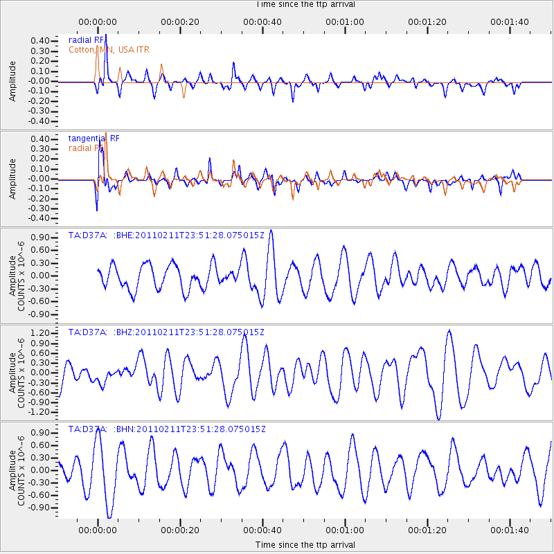
D37A Cotton, MN, USA - Earthquake Result Viewer
*The percent match for this event was below the threshold and hence no stack was calculated.
| Earthquake location: |
Near Coast Of Central Chile |
| Earthquake latitude/longitude: |
-37.2/-73.2 |
| Earthquake time(UTC): |
2011/02/11 (042) 23:39:21 GMT |
| Earthquake Depth: |
15 km |
| Earthquake Magnitude: |
5.5 MB, 5.7 MS, 6.0 MW, 5.9 MW |
| Earthquake Catalog/Contributor: |
WHDF/NEIC |
|
| Network: |
TA USArray Transportable Network (new EarthScope stations) |
| Station: |
D37A Cotton, MN, USA |
| Lat/Lon: |
47.16 N/92.43 W |
| Elevation: |
413 m |
|
| Distance: |
85.7 deg |
| Az: |
346.975 deg |
| Baz: |
164.71 deg |
| Ray Param: |
$rayparam |
*The percent match for this event was below the threshold and hence was not used in the summary stack. |
|
| Radial Match: |
49.18539 % |
| Radial Bump: |
328 |
| Transverse Match: |
64.15064 % |
| Transverse Bump: |
400 |
| SOD ConfigId: |
350818 |
| Insert Time: |
2011-07-22 11:45:50.130 +0000 |
| GWidth: |
2.5 |
| Max Bumps: |
400 |
| Tol: |
0.001 |
|
Signal To Noise
| Channel | StoN | STA | LTA |
| TA:D37A: :BHZ:20110211T23:51:28.075015Z | 0.65880334 | 2.4255573E-7 | 3.6817625E-7 |
| TA:D37A: :BHN:20110211T23:51:28.075015Z | 2.3467388 | 7.795561E-7 | 3.32187E-7 |
| TA:D37A: :BHE:20110211T23:51:28.075015Z | 0.46719304 | 1.2728277E-7 | 2.7244153E-7 |
| Arrivals |
| Ps | |
| PpPs | |
| PsPs/PpSs | |


