You are here: Home > Network List > TA - USArray Transportable Network (new EarthScope stations) Stations List
> Station 535A Dale, TX, USA > Earthquake Result Viewer
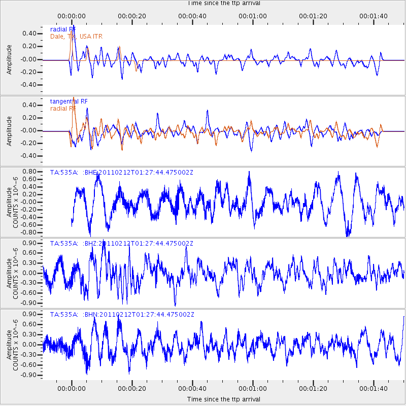
535A Dale, TX, USA - Earthquake Result Viewer
*The percent match for this event was below the threshold and hence no stack was calculated.
| Earthquake location: |
Central Chile |
| Earthquake latitude/longitude: |
-37.0/-73.0 |
| Earthquake time(UTC): |
2011/02/12 (043) 01:17:01 GMT |
| Earthquake Depth: |
16 km |
| Earthquake Magnitude: |
5.8 MS, 5.4 MB, 6.1 MW, 6.1 MW |
| Earthquake Catalog/Contributor: |
WHDF/NEIC |
|
| Network: |
TA USArray Transportable Network (new EarthScope stations) |
| Station: |
535A Dale, TX, USA |
| Lat/Lon: |
30.03 N/97.57 W |
| Elevation: |
170 m |
|
| Distance: |
70.6 deg |
| Az: |
337.479 deg |
| Baz: |
159.301 deg |
| Ray Param: |
$rayparam |
*The percent match for this event was below the threshold and hence was not used in the summary stack. |
|
| Radial Match: |
61.932323 % |
| Radial Bump: |
400 |
| Transverse Match: |
47.68348 % |
| Transverse Bump: |
400 |
| SOD ConfigId: |
350818 |
| Insert Time: |
2011-07-26 06:51:18.818 +0000 |
| GWidth: |
2.5 |
| Max Bumps: |
400 |
| Tol: |
0.001 |
|
Signal To Noise
| Channel | StoN | STA | LTA |
| TA:535A: :BHZ:20110212T01:27:44.475002Z | 1.3217853 | 3.0903544E-7 | 2.3380154E-7 |
| TA:535A: :BHN:20110212T01:27:44.475002Z | 1.7105844 | 2.7277244E-7 | 1.5946155E-7 |
| TA:535A: :BHE:20110212T01:27:44.475002Z | 0.57783014 | 1.9838214E-7 | 3.4332257E-7 |
| Arrivals |
| Ps | |
| PpPs | |
| PsPs/PpSs | |


