You are here: Home > Network List > TA - USArray Transportable Network (new EarthScope stations) Stations List
> Station N36A Muff Farm, Clarinda, IA, USA > Earthquake Result Viewer
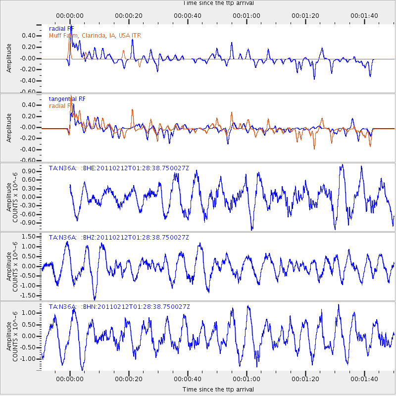
N36A Muff Farm, Clarinda, IA, USA - Earthquake Result Viewer
*The percent match for this event was below the threshold and hence no stack was calculated.
| Earthquake location: |
Central Chile |
| Earthquake latitude/longitude: |
-37.0/-73.0 |
| Earthquake time(UTC): |
2011/02/12 (043) 01:17:01 GMT |
| Earthquake Depth: |
16 km |
| Earthquake Magnitude: |
5.8 MS, 5.4 MB, 6.1 MW, 6.1 MW |
| Earthquake Catalog/Contributor: |
WHDF/NEIC |
|
| Network: |
TA USArray Transportable Network (new EarthScope stations) |
| Station: |
N36A Muff Farm, Clarinda, IA, USA |
| Lat/Lon: |
40.82 N/94.96 W |
| Elevation: |
349 m |
|
| Distance: |
80.1 deg |
| Az: |
343.218 deg |
| Baz: |
162.275 deg |
| Ray Param: |
$rayparam |
*The percent match for this event was below the threshold and hence was not used in the summary stack. |
|
| Radial Match: |
52.84822 % |
| Radial Bump: |
400 |
| Transverse Match: |
64.16649 % |
| Transverse Bump: |
400 |
| SOD ConfigId: |
350818 |
| Insert Time: |
2011-07-26 06:54:33.474 +0000 |
| GWidth: |
2.5 |
| Max Bumps: |
400 |
| Tol: |
0.001 |
|
Signal To Noise
| Channel | StoN | STA | LTA |
| TA:N36A: :BHZ:20110212T01:28:38.750027Z | 2.3167217 | 6.339866E-7 | 2.7365678E-7 |
| TA:N36A: :BHN:20110212T01:28:38.750027Z | 1.6543115 | 8.7198504E-7 | 5.2709845E-7 |
| TA:N36A: :BHE:20110212T01:28:38.750027Z | 1.4700472 | 4.1206394E-7 | 2.803066E-7 |
| Arrivals |
| Ps | |
| PpPs | |
| PsPs/PpSs | |


