You are here: Home > Network List > MN - MEDNET Project Stations List
> Station TIP Timpagrande, Italy > Earthquake Result Viewer
TIP Timpagrande, Italy - Earthquake Result Viewer
| Earthquake location: |
North Of Ascension Island |
| Earthquake latitude/longitude: |
0.1/-17.0 |
| Earthquake time(UTC): |
2011/02/12 (043) 02:53:15 GMT |
| Earthquake Depth: |
10 km |
| Earthquake Magnitude: |
5.5 MB, 5.6 MW |
| Earthquake Catalog/Contributor: |
WHDF/NEIC |
|
| Network: |
MN MEDNET Project |
| Station: |
TIP Timpagrande, Italy |
| Lat/Lon: |
39.18 N/16.76 E |
| Elevation: |
789 m |
|
| Distance: |
49.7 deg |
| Az: |
34.517 deg |
| Baz: |
226.808 deg |
| Ray Param: |
0.06853993 |
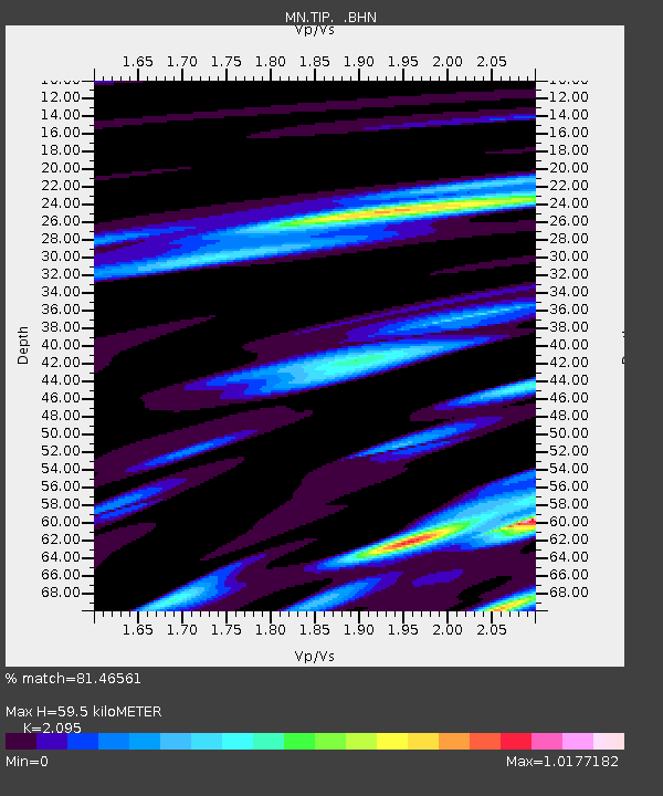
| Estimated Moho Depth: |
59.5 km |
| Estimated Crust Vp/Vs: |
2.10 |
| Assumed Crust Vp: |
6.1 km/s |
| Estimated Crust Vs: |
2.912 km/s |
| Estimated Crust Poisson's Ratio: |
0.35 |
|
| Radial Match: |
81.46561 % |
| Radial Bump: |
277 |
| Transverse Match: |
76.0276 % |
| Transverse Bump: |
341 |
| SOD ConfigId: |
350818 |
| Insert Time: |
2011-07-26 07:03:00.603 +0000 |
| GWidth: |
2.5 |
| Max Bumps: |
400 |
| Tol: |
0.001 |
|
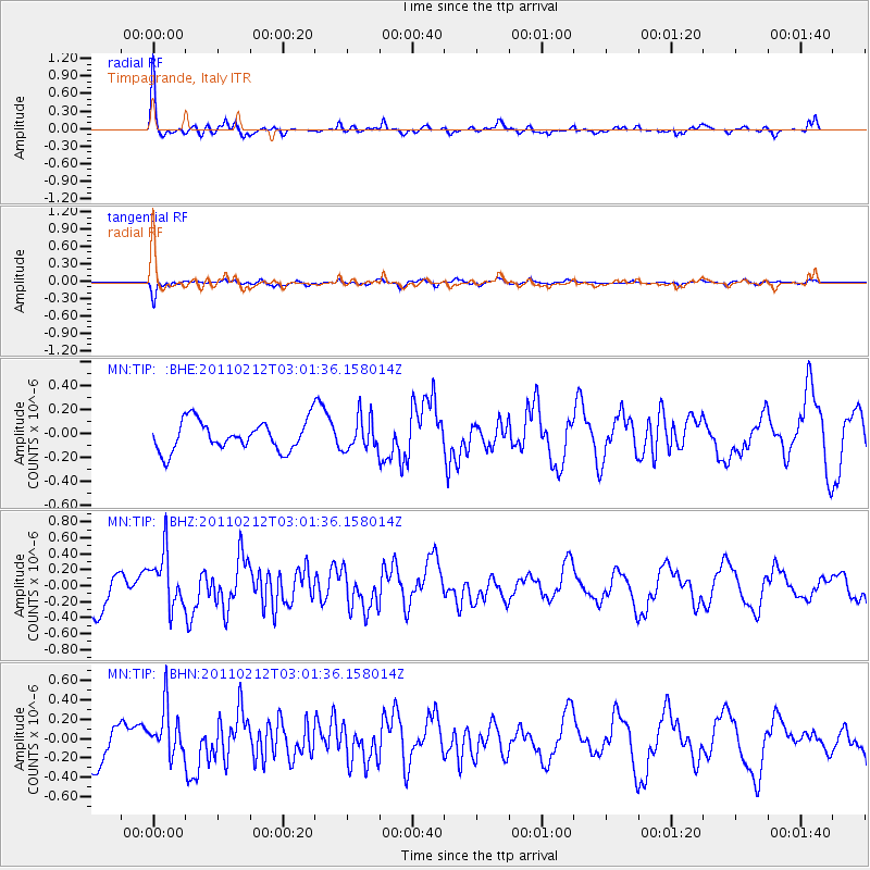
Signal To Noise
| Channel | StoN | STA | LTA |
| MN:TIP: :BHZ:20110212T03:01:36.158014Z | 1.9759029 | 3.4350398E-7 | 1.738466E-7 |
| MN:TIP: :BHN:20110212T03:01:36.158014Z | 1.8504463 | 2.536952E-7 | 1.3709946E-7 |
| MN:TIP: :BHE:20110212T03:01:36.158014Z | 1.1199552 | 1.3858576E-7 | 1.2374225E-7 |
| Arrivals |
| Ps | 11 SECOND |
| PpPs | 29 SECOND |
| PsPs/PpSs | 40 SECOND |


