You are here: Home > Network List > TA - USArray Transportable Network (new EarthScope stations) Stations List
> Station 633A Saathoff Ranch, Hondo, TX, USA > Earthquake Result Viewer
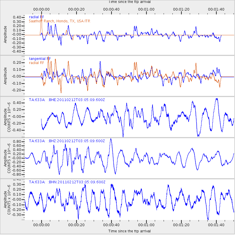
633A Saathoff Ranch, Hondo, TX, USA - Earthquake Result Viewer
*The percent match for this event was below the threshold and hence no stack was calculated.
| Earthquake location: |
North Of Ascension Island |
| Earthquake latitude/longitude: |
0.1/-17.0 |
| Earthquake time(UTC): |
2011/02/12 (043) 02:53:15 GMT |
| Earthquake Depth: |
10 km |
| Earthquake Magnitude: |
5.5 MB, 5.6 MW |
| Earthquake Catalog/Contributor: |
WHDF/NEIC |
|
| Network: |
TA USArray Transportable Network (new EarthScope stations) |
| Station: |
633A Saathoff Ranch, Hondo, TX, USA |
| Lat/Lon: |
29.46 N/99.18 W |
| Elevation: |
320 m |
|
| Distance: |
83.1 deg |
| Az: |
299.517 deg |
| Baz: |
93.786 deg |
| Ray Param: |
$rayparam |
*The percent match for this event was below the threshold and hence was not used in the summary stack. |
|
| Radial Match: |
55.063454 % |
| Radial Bump: |
400 |
| Transverse Match: |
42.233772 % |
| Transverse Bump: |
400 |
| SOD ConfigId: |
350818 |
| Insert Time: |
2011-07-26 07:07:20.686 +0000 |
| GWidth: |
2.5 |
| Max Bumps: |
400 |
| Tol: |
0.001 |
|
Signal To Noise
| Channel | StoN | STA | LTA |
| TA:633A: :BHZ:20110212T03:05:09.600Z | 1.659656 | 2.5550457E-7 | 1.5395031E-7 |
| TA:633A: :BHN:20110212T03:05:09.600Z | 0.8716472 | 1.258587E-7 | 1.443918E-7 |
| TA:633A: :BHE:20110212T03:05:09.600Z | 0.7931916 | 1.3567065E-7 | 1.7104396E-7 |
| Arrivals |
| Ps | |
| PpPs | |
| PsPs/PpSs | |


