You are here: Home > Network List > TA - USArray Transportable Network (new EarthScope stations) Stations List
> Station B32A Ashes, Strandquist, MN, USA > Earthquake Result Viewer
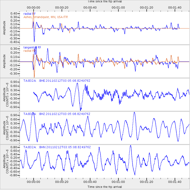
B32A Ashes, Strandquist, MN, USA - Earthquake Result Viewer
*The percent match for this event was below the threshold and hence no stack was calculated.
| Earthquake location: |
North Of Ascension Island |
| Earthquake latitude/longitude: |
0.1/-17.0 |
| Earthquake time(UTC): |
2011/02/12 (043) 02:53:15 GMT |
| Earthquake Depth: |
10 km |
| Earthquake Magnitude: |
5.5 MB, 5.6 MW |
| Earthquake Catalog/Contributor: |
WHDF/NEIC |
|
| Network: |
TA USArray Transportable Network (new EarthScope stations) |
| Station: |
B32A Ashes, Strandquist, MN, USA |
| Lat/Lon: |
48.40 N/96.54 W |
| Elevation: |
335 m |
|
| Distance: |
83.0 deg |
| Az: |
318.676 deg |
| Baz: |
97.801 deg |
| Ray Param: |
$rayparam |
*The percent match for this event was below the threshold and hence was not used in the summary stack. |
|
| Radial Match: |
53.518856 % |
| Radial Bump: |
361 |
| Transverse Match: |
68.49844 % |
| Transverse Bump: |
400 |
| SOD ConfigId: |
350818 |
| Insert Time: |
2011-07-26 07:09:17.189 +0000 |
| GWidth: |
2.5 |
| Max Bumps: |
400 |
| Tol: |
0.001 |
|
Signal To Noise
| Channel | StoN | STA | LTA |
| TA:B32A: :BHZ:20110212T03:05:08.824976Z | 1.4763464 | 7.240572E-7 | 4.904386E-7 |
| TA:B32A: :BHN:20110212T03:05:08.824976Z | 0.7460985 | 2.9554843E-7 | 3.9612522E-7 |
| TA:B32A: :BHE:20110212T03:05:08.824976Z | 2.9410648 | 6.46069E-7 | 2.196718E-7 |
| Arrivals |
| Ps | |
| PpPs | |
| PsPs/PpSs | |


