You are here: Home > Network List > AZ - ANZA Regional Network Stations List
> Station SMER AZ.SMER > Earthquake Result Viewer
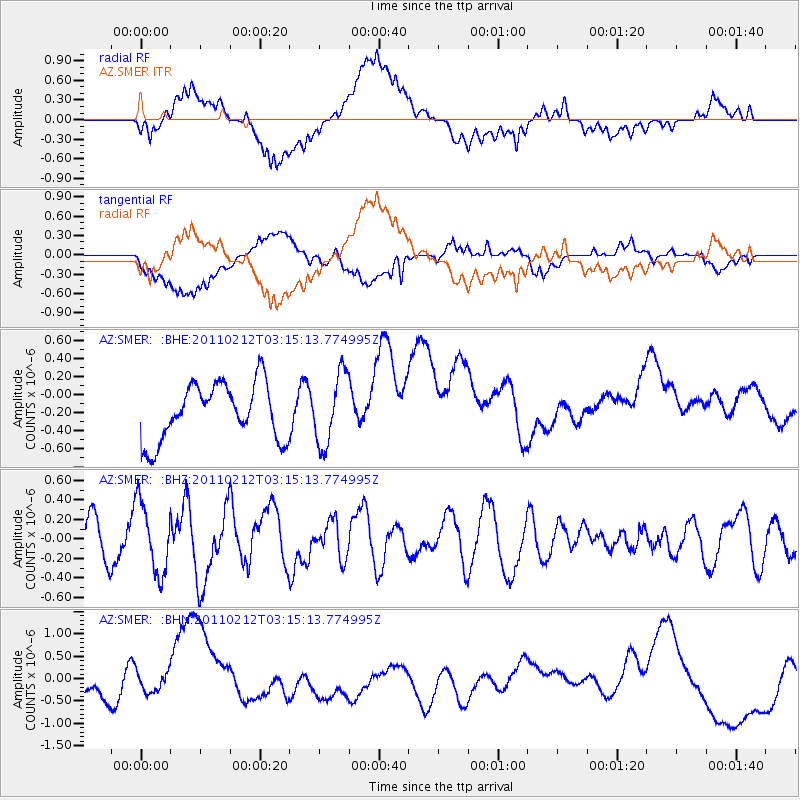
SMER AZ.SMER - Earthquake Result Viewer
*The percent match for this event was below the threshold and hence no stack was calculated.
| Earthquake location: |
Kermadec Islands Region |
| Earthquake latitude/longitude: |
-31.2/-177.8 |
| Earthquake time(UTC): |
2011/02/12 (043) 03:03:04 GMT |
| Earthquake Depth: |
10 km |
| Earthquake Magnitude: |
5.7 MS, 5.2 MB, 5.6 MW |
| Earthquake Catalog/Contributor: |
WHDF/NEIC |
|
| Network: |
AZ ANZA Regional Network |
| Station: |
SMER AZ.SMER |
| Lat/Lon: |
33.46 N/117.17 W |
| Elevation: |
355 m |
|
| Distance: |
86.1 deg |
| Az: |
46.91 deg |
| Baz: |
228.437 deg |
| Ray Param: |
$rayparam |
*The percent match for this event was below the threshold and hence was not used in the summary stack. |
|
| Radial Match: |
49.202698 % |
| Radial Bump: |
400 |
| Transverse Match: |
33.296375 % |
| Transverse Bump: |
400 |
| SOD ConfigId: |
350818 |
| Insert Time: |
2011-07-26 07:15:40.822 +0000 |
| GWidth: |
2.5 |
| Max Bumps: |
400 |
| Tol: |
0.001 |
|
Signal To Noise
| Channel | StoN | STA | LTA |
| AZ:SMER: :BHZ:20110212T03:15:13.774995Z | 1.2423998 | 3.584404E-7 | 2.885065E-7 |
| AZ:SMER: :BHN:20110212T03:15:13.774995Z | 0.5408514 | 2.3353077E-7 | 4.317836E-7 |
| AZ:SMER: :BHE:20110212T03:15:13.774995Z | 1.2694207 | 3.9782972E-7 | 3.133947E-7 |
| Arrivals |
| Ps | |
| PpPs | |
| PsPs/PpSs | |


