You are here: Home > Network List > CI - Caltech Regional Seismic Network Stations List
> Station SMM Simmler, CA, USA > Earthquake Result Viewer
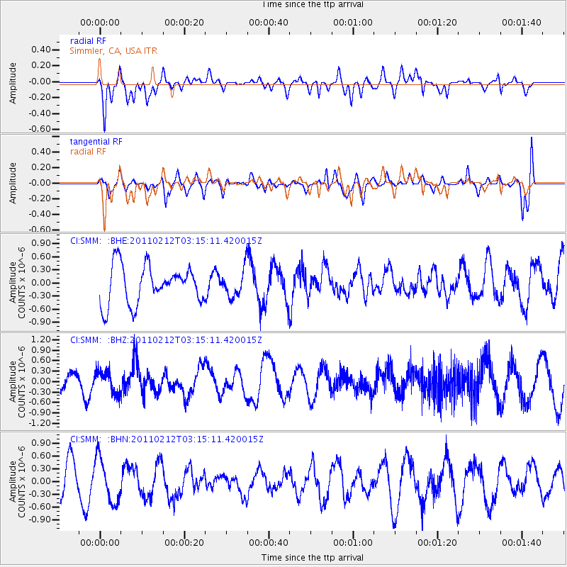
SMM Simmler, CA, USA - Earthquake Result Viewer
*The percent match for this event was below the threshold and hence no stack was calculated.
| Earthquake location: |
Kermadec Islands Region |
| Earthquake latitude/longitude: |
-31.2/-177.8 |
| Earthquake time(UTC): |
2011/02/12 (043) 03:03:04 GMT |
| Earthquake Depth: |
10 km |
| Earthquake Magnitude: |
5.7 MS, 5.2 MB, 5.6 MW |
| Earthquake Catalog/Contributor: |
WHDF/NEIC |
|
| Network: |
CI Caltech Regional Seismic Network |
| Station: |
SMM Simmler, CA, USA |
| Lat/Lon: |
35.31 N/120.00 W |
| Elevation: |
599 m |
|
| Distance: |
85.6 deg |
| Az: |
43.959 deg |
| Baz: |
226.636 deg |
| Ray Param: |
$rayparam |
*The percent match for this event was below the threshold and hence was not used in the summary stack. |
|
| Radial Match: |
59.667965 % |
| Radial Bump: |
400 |
| Transverse Match: |
41.44289 % |
| Transverse Bump: |
400 |
| SOD ConfigId: |
350818 |
| Insert Time: |
2011-07-26 07:17:33.777 +0000 |
| GWidth: |
2.5 |
| Max Bumps: |
400 |
| Tol: |
0.001 |
|
Signal To Noise
| Channel | StoN | STA | LTA |
| CI:SMM: :BHZ:20110212T03:15:11.420015Z | 1.3211347 | 3.2267104E-7 | 2.442378E-7 |
| CI:SMM: :BHN:20110212T03:15:11.420015Z | 1.4033116 | 5.2344376E-7 | 3.730061E-7 |
| CI:SMM: :BHE:20110212T03:15:11.420015Z | 0.75338095 | 3.2719717E-7 | 4.3430506E-7 |
| Arrivals |
| Ps | |
| PpPs | |
| PsPs/PpSs | |


