You are here: Home > Network List > TA - USArray Transportable Network (new EarthScope stations) Stations List
> Station 433A Art, TX, USA > Earthquake Result Viewer
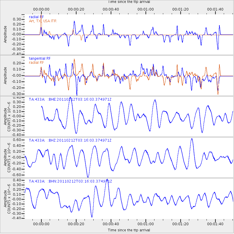
433A Art, TX, USA - Earthquake Result Viewer
*The percent match for this event was below the threshold and hence no stack was calculated.
| Earthquake location: |
Kermadec Islands Region |
| Earthquake latitude/longitude: |
-31.2/-177.8 |
| Earthquake time(UTC): |
2011/02/12 (043) 03:03:04 GMT |
| Earthquake Depth: |
10 km |
| Earthquake Magnitude: |
5.7 MS, 5.2 MB, 5.6 MW |
| Earthquake Catalog/Contributor: |
WHDF/NEIC |
|
| Network: |
TA USArray Transportable Network (new EarthScope stations) |
| Station: |
433A Art, TX, USA |
| Lat/Lon: |
30.75 N/99.09 W |
| Elevation: |
447 m |
|
| Distance: |
96.8 deg |
| Az: |
58.235 deg |
| Baz: |
237.771 deg |
| Ray Param: |
$rayparam |
*The percent match for this event was below the threshold and hence was not used in the summary stack. |
|
| Radial Match: |
50.382835 % |
| Radial Bump: |
400 |
| Transverse Match: |
41.76078 % |
| Transverse Bump: |
400 |
| SOD ConfigId: |
350818 |
| Insert Time: |
2011-07-26 07:20:29.170 +0000 |
| GWidth: |
2.5 |
| Max Bumps: |
400 |
| Tol: |
0.001 |
|
Signal To Noise
| Channel | StoN | STA | LTA |
| TA:433A: :BHZ:20110212T03:16:03.374971Z | 1.4812571 | 1.9724072E-7 | 1.3315766E-7 |
| TA:433A: :BHN:20110212T03:16:03.374971Z | 1.0627075 | 2.4561055E-7 | 2.3111772E-7 |
| TA:433A: :BHE:20110212T03:16:03.374971Z | 0.8500723 | 1.4663883E-7 | 1.7250159E-7 |
| Arrivals |
| Ps | |
| PpPs | |
| PsPs/PpSs | |


