You are here: Home > Network List > 2G - Testing of the effectiveness of incorporating seismic data in seismic hazard ass Stations List
> Station IUGFS Indiana Univ Geologic Field Station, Cardwell, MT > Earthquake Result Viewer
IUGFS Indiana Univ Geologic Field Station, Cardwell, MT - Earthquake Result Viewer
| Earthquake location: |
Vanuatu Islands Region |
| Earthquake latitude/longitude: |
-20.5/172.5 |
| Earthquake time(UTC): |
2014/01/22 (022) 10:20:30 GMT |
| Earthquake Depth: |
10 km |
| Earthquake Magnitude: |
5.6 MWB, 5.6 MWC |
| Earthquake Catalog/Contributor: |
NEIC PDE/NEIC COMCAT |
|
| Network: |
2G Testing of the effectiveness of incorporating seismic data in seismic hazard ass |
| Station: |
IUGFS Indiana Univ Geologic Field Station, Cardwell, MT |
| Lat/Lon: |
45.73 N/111.97 W |
| Elevation: |
1634 m |
|
| Distance: |
94.8 deg |
| Az: |
42.889 deg |
| Baz: |
245.631 deg |
| Ray Param: |
0.040946953 |
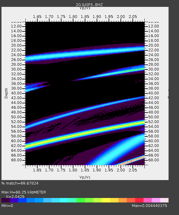
| Estimated Moho Depth: |
68.25 km |
| Estimated Crust Vp/Vs: |
2.04 |
| Assumed Crust Vp: |
6.35 km/s |
| Estimated Crust Vs: |
3.109 km/s |
| Estimated Crust Poisson's Ratio: |
0.34 |
|
| Radial Match: |
99.67824 % |
| Radial Bump: |
18 |
| Transverse Match: |
99.86037 % |
| Transverse Bump: |
19 |
| SOD ConfigId: |
3390531 |
| Insert Time: |
2019-04-10 01:58:50.467 +0000 |
| GWidth: |
2.5 |
| Max Bumps: |
400 |
| Tol: |
0.001 |
|

Signal To Noise
| Channel | StoN | STA | LTA |
| 2G:IUGFS: :BHZ:20140122T10:33:21.100024Z | 1.7676681 | 1.5471278E-7 | 8.752365E-8 |
| 2G:IUGFS: :BHN:20140122T10:33:21.100024Z | 1.7491037 | 1.8574575E-7 | 1.0619482E-7 |
| 2G:IUGFS: :BHE:20140122T10:33:21.100024Z | 0.99684966 | 4.5608988E-9 | 4.5753126E-9 |
| Arrivals |
| Ps | 11 SECOND |
| PpPs | 32 SECOND |
| PsPs/PpSs | 44 SECOND |


