You are here: Home > Network List > AU - Australian Seismological Centre Stations List
> Station KNRA Kunnunarra, Western Australia > Earthquake Result Viewer
KNRA Kunnunarra, Western Australia - Earthquake Result Viewer
| Earthquake location: |
Tonga Islands |
| Earthquake latitude/longitude: |
-20.9/-175.7 |
| Earthquake time(UTC): |
2011/02/12 (043) 17:57:56 GMT |
| Earthquake Depth: |
90 km |
| Earthquake Magnitude: |
6.0 MB, 6.1 MW, 6.1 MW |
| Earthquake Catalog/Contributor: |
WHDF/NEIC |
|
| Network: |
AU Australian Seismological Centre |
| Station: |
KNRA Kunnunarra, Western Australia |
| Lat/Lon: |
15.68 S/128.76 E |
| Elevation: |
101 m |
|
| Distance: |
52.8 deg |
| Az: |
265.821 deg |
| Baz: |
104.497 deg |
| Ray Param: |
0.06624322 |
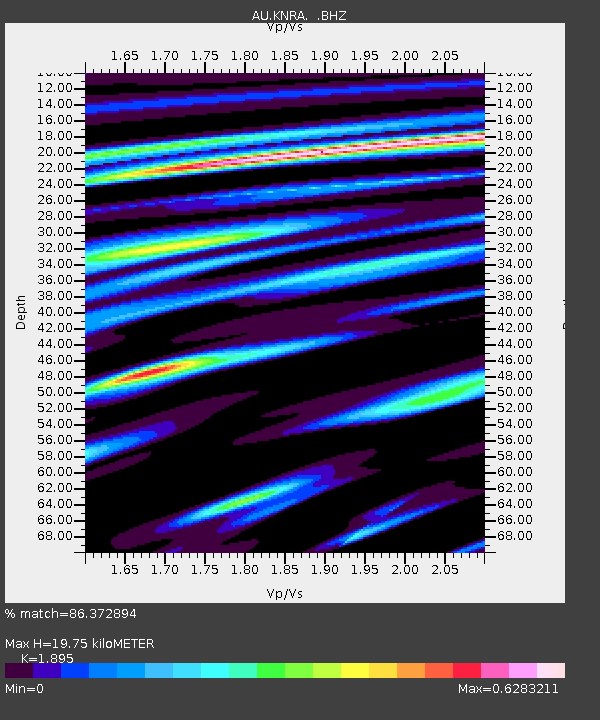
| Estimated Moho Depth: |
19.75 km |
| Estimated Crust Vp/Vs: |
1.89 |
| Assumed Crust Vp: |
6.397 km/s |
| Estimated Crust Vs: |
3.376 km/s |
| Estimated Crust Poisson's Ratio: |
0.31 |
|
| Radial Match: |
86.372894 % |
| Radial Bump: |
369 |
| Transverse Match: |
62.8374 % |
| Transverse Bump: |
400 |
| SOD ConfigId: |
350818 |
| Insert Time: |
2011-07-26 07:31:51.740 +0000 |
| GWidth: |
2.5 |
| Max Bumps: |
400 |
| Tol: |
0.001 |
|

Signal To Noise
| Channel | StoN | STA | LTA |
| AU:KNRA: :BHZ:20110212T18:06:32.169978Z | 20.650654 | 3.840958E-6 | 1.8599692E-7 |
| AU:KNRA: :BHN:20110212T18:06:32.169978Z | 1.3848085 | 3.4789576E-7 | 2.51223E-7 |
| AU:KNRA: :BHE:20110212T18:06:32.169978Z | 7.6508884 | 1.6629967E-6 | 2.1735994E-7 |
| Arrivals |
| Ps | 2.9 SECOND |
| PpPs | 8.5 SECOND |
| PsPs/PpSs | 11 SECOND |


