You are here: Home > Network List > BK - Berkeley Digital Seismograph Network Stations List
> Station HUMO Hull Mountain, OR > Earthquake Result Viewer
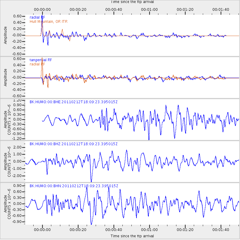
HUMO Hull Mountain, OR - Earthquake Result Viewer
*The percent match for this event was below the threshold and hence no stack was calculated.
| Earthquake location: |
Tonga Islands |
| Earthquake latitude/longitude: |
-20.9/-175.7 |
| Earthquake time(UTC): |
2011/02/12 (043) 17:57:56 GMT |
| Earthquake Depth: |
90 km |
| Earthquake Magnitude: |
6.0 MB, 6.1 MW, 6.1 MW |
| Earthquake Catalog/Contributor: |
WHDF/NEIC |
|
| Network: |
BK Berkeley Digital Seismograph Network |
| Station: |
HUMO Hull Mountain, OR |
| Lat/Lon: |
42.61 N/122.96 W |
| Elevation: |
555 m |
|
| Distance: |
79.7 deg |
| Az: |
36.66 deg |
| Baz: |
229.133 deg |
| Ray Param: |
$rayparam |
*The percent match for this event was below the threshold and hence was not used in the summary stack. |
|
| Radial Match: |
70.578 % |
| Radial Bump: |
400 |
| Transverse Match: |
58.66492 % |
| Transverse Bump: |
390 |
| SOD ConfigId: |
350818 |
| Insert Time: |
2011-07-26 07:38:26.205 +0000 |
| GWidth: |
2.5 |
| Max Bumps: |
400 |
| Tol: |
0.001 |
|
Signal To Noise
| Channel | StoN | STA | LTA |
| BK:HUMO:00:BHZ:20110212T18:09:23.395015Z | 1.9729171 | 5.345788E-7 | 2.7095857E-7 |
| BK:HUMO:00:BHN:20110212T18:09:23.395015Z | 2.0036666 | 2.10618E-7 | 1.0511628E-7 |
| BK:HUMO:00:BHE:20110212T18:09:23.395015Z | 1.2356619 | 2.2699155E-7 | 1.8370038E-7 |
| Arrivals |
| Ps | |
| PpPs | |
| PsPs/PpSs | |


