You are here: Home > Network List > CI - Caltech Regional Seismic Network Stations List
> Station SHO Shoshone, CA, USA > Earthquake Result Viewer
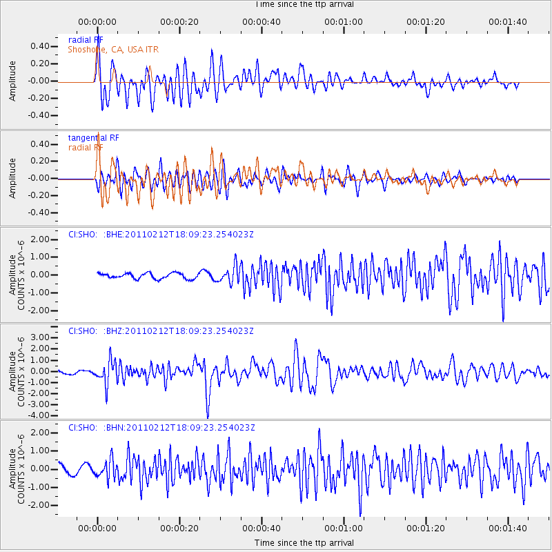
SHO Shoshone, CA, USA - Earthquake Result Viewer
*The percent match for this event was below the threshold and hence no stack was calculated.
| Earthquake location: |
Tonga Islands |
| Earthquake latitude/longitude: |
-20.9/-175.7 |
| Earthquake time(UTC): |
2011/02/12 (043) 17:57:56 GMT |
| Earthquake Depth: |
90 km |
| Earthquake Magnitude: |
6.0 MB, 6.1 MW, 6.1 MW |
| Earthquake Catalog/Contributor: |
WHDF/NEIC |
|
| Network: |
CI Caltech Regional Seismic Network |
| Station: |
SHO Shoshone, CA, USA |
| Lat/Lon: |
35.90 N/116.28 W |
| Elevation: |
451 m |
|
| Distance: |
79.7 deg |
| Az: |
45.266 deg |
| Baz: |
234.9 deg |
| Ray Param: |
$rayparam |
*The percent match for this event was below the threshold and hence was not used in the summary stack. |
|
| Radial Match: |
77.37448 % |
| Radial Bump: |
400 |
| Transverse Match: |
74.25621 % |
| Transverse Bump: |
400 |
| SOD ConfigId: |
350818 |
| Insert Time: |
2011-07-26 07:42:42.799 +0000 |
| GWidth: |
2.5 |
| Max Bumps: |
400 |
| Tol: |
0.001 |
|
Signal To Noise
| Channel | StoN | STA | LTA |
| CI:SHO: :BHZ:20110212T18:09:23.254023Z | 8.207044 | 1.0439861E-6 | 1.2720612E-7 |
| CI:SHO: :BHN:20110212T18:09:23.254023Z | 2.3047807 | 4.899073E-7 | 2.1256135E-7 |
| CI:SHO: :BHE:20110212T18:09:23.254023Z | 2.9936686 | 4.6700734E-7 | 1.5599834E-7 |
| Arrivals |
| Ps | |
| PpPs | |
| PsPs/PpSs | |


