You are here: Home > Network List > CI - Caltech Regional Seismic Network Stations List
> Station SWS Sam W. Stewart, Westmorland, CA, USA > Earthquake Result Viewer
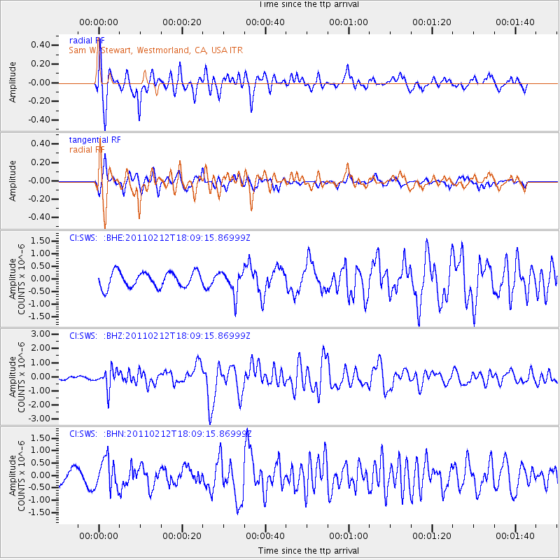
SWS Sam W. Stewart, Westmorland, CA, USA - Earthquake Result Viewer
*The percent match for this event was below the threshold and hence no stack was calculated.
| Earthquake location: |
Tonga Islands |
| Earthquake latitude/longitude: |
-20.9/-175.7 |
| Earthquake time(UTC): |
2011/02/12 (043) 17:57:56 GMT |
| Earthquake Depth: |
90 km |
| Earthquake Magnitude: |
6.0 MB, 6.1 MW, 6.1 MW |
| Earthquake Catalog/Contributor: |
WHDF/NEIC |
|
| Network: |
CI Caltech Regional Seismic Network |
| Station: |
SWS Sam W. Stewart, Westmorland, CA, USA |
| Lat/Lon: |
32.94 N/115.80 W |
| Elevation: |
140 m |
|
| Distance: |
78.3 deg |
| Az: |
47.968 deg |
| Baz: |
235.687 deg |
| Ray Param: |
$rayparam |
*The percent match for this event was below the threshold and hence was not used in the summary stack. |
|
| Radial Match: |
74.648705 % |
| Radial Bump: |
400 |
| Transverse Match: |
55.815014 % |
| Transverse Bump: |
331 |
| SOD ConfigId: |
350818 |
| Insert Time: |
2011-07-26 07:43:26.684 +0000 |
| GWidth: |
2.5 |
| Max Bumps: |
400 |
| Tol: |
0.001 |
|
Signal To Noise
| Channel | StoN | STA | LTA |
| CI:SWS: :BHZ:20110212T18:09:15.86999Z | 6.3649445 | 6.816695E-7 | 1.0709748E-7 |
| CI:SWS: :BHN:20110212T18:09:15.86999Z | 1.9262896 | 5.995021E-7 | 3.1122116E-7 |
| CI:SWS: :BHE:20110212T18:09:15.86999Z | 1.5507755 | 4.635523E-7 | 2.9891643E-7 |
| Arrivals |
| Ps | |
| PpPs | |
| PsPs/PpSs | |


