You are here: Home > Network List > CI - Caltech Regional Seismic Network Stations List
> Station LGU LGU, Camarillo, CA, USA > Earthquake Result Viewer
LGU LGU, Camarillo, CA, USA - Earthquake Result Viewer
*The percent match for this event was below the threshold and hence no stack was calculated.
| Earthquake location: |
Tonga Islands |
| Earthquake latitude/longitude: |
-20.9/-175.7 |
| Earthquake time(UTC): |
2011/02/12 (043) 17:57:56 GMT |
| Earthquake Depth: |
90 km |
| Earthquake Magnitude: |
6.0 MB, 6.1 MW, 6.1 MW |
| Earthquake Catalog/Contributor: |
WHDF/NEIC |
|
| Network: |
CI Caltech Regional Seismic Network |
| Station: |
LGU LGU, Camarillo, CA, USA |
| Lat/Lon: |
34.11 N/119.07 W |
| Elevation: |
416 m |
|
| Distance: |
76.8 deg |
| Az: |
45.373 deg |
| Baz: |
233.328 deg |
| Ray Param: |
$rayparam |
*The percent match for this event was below the threshold and hence was not used in the summary stack. |
|
| Radial Match: |
79.21015 % |
| Radial Bump: |
400 |
| Transverse Match: |
76.242836 % |
| Transverse Bump: |
400 |
| SOD ConfigId: |
350818 |
| Insert Time: |
2011-07-26 07:46:05.814 +0000 |
| GWidth: |
2.5 |
| Max Bumps: |
400 |
| Tol: |
0.001 |
|
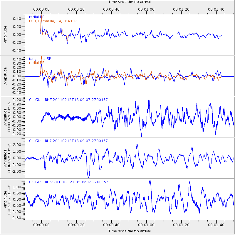
Signal To Noise
| Channel | StoN | STA | LTA |
| CI:LGU: :BHZ:20110212T18:09:07.270015Z | 3.9020443 | 6.695417E-7 | 1.7158742E-7 |
| CI:LGU: :BHN:20110212T18:09:07.270015Z | 1.13705 | 2.5045188E-7 | 2.2026462E-7 |
| CI:LGU: :BHE:20110212T18:09:07.270015Z | 2.343787 | 3.2647182E-7 | 1.3929244E-7 |
| Arrivals |
| Ps | |
| PpPs | |
| PsPs/PpSs | |


