You are here: Home > Network List > CI - Caltech Regional Seismic Network Stations List
> Station FMP Fort MacArthur Park, Pt. Fermin San Pedro, CA, USA > Earthquake Result Viewer
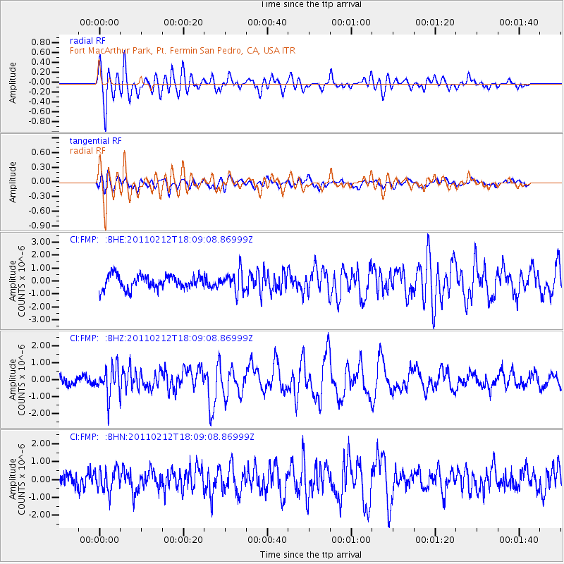
FMP Fort MacArthur Park, Pt. Fermin San Pedro, CA, USA - Earthquake Result Viewer
*The percent match for this event was below the threshold and hence no stack was calculated.
| Earthquake location: |
Tonga Islands |
| Earthquake latitude/longitude: |
-20.9/-175.7 |
| Earthquake time(UTC): |
2011/02/12 (043) 17:57:56 GMT |
| Earthquake Depth: |
90 km |
| Earthquake Magnitude: |
6.0 MB, 6.1 MW, 6.1 MW |
| Earthquake Catalog/Contributor: |
WHDF/NEIC |
|
| Network: |
CI Caltech Regional Seismic Network |
| Station: |
FMP Fort MacArthur Park, Pt. Fermin San Pedro, CA, USA |
| Lat/Lon: |
33.71 N/118.29 W |
| Elevation: |
89 m |
|
| Distance: |
77.0 deg |
| Az: |
46.09 deg |
| Baz: |
233.919 deg |
| Ray Param: |
$rayparam |
*The percent match for this event was below the threshold and hence was not used in the summary stack. |
|
| Radial Match: |
81.003586 % |
| Radial Bump: |
400 |
| Transverse Match: |
72.64514 % |
| Transverse Bump: |
400 |
| SOD ConfigId: |
350818 |
| Insert Time: |
2011-07-26 07:47:33.876 +0000 |
| GWidth: |
2.5 |
| Max Bumps: |
400 |
| Tol: |
0.001 |
|
Signal To Noise
| Channel | StoN | STA | LTA |
| CI:FMP: :BHZ:20110212T18:09:08.86999Z | 2.6913342 | 8.658617E-7 | 3.217221E-7 |
| CI:FMP: :BHN:20110212T18:09:08.86999Z | 1.4876896 | 6.1558194E-7 | 4.1378385E-7 |
| CI:FMP: :BHE:20110212T18:09:08.86999Z | 1.6086975 | 8.304061E-7 | 5.1619776E-7 |
| Arrivals |
| Ps | |
| PpPs | |
| PsPs/PpSs | |


