You are here: Home > Network List > IC - New China Digital Seismograph Network Stations List
> Station ENH Enshi, Hubei Province, China > Earthquake Result Viewer
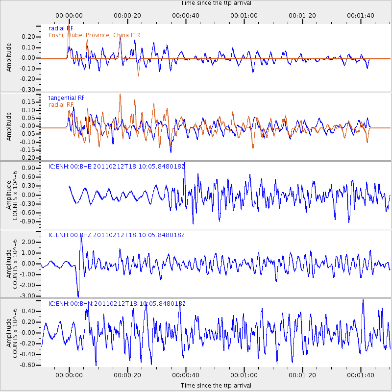
ENH Enshi, Hubei Province, China - Earthquake Result Viewer
*The percent match for this event was below the threshold and hence no stack was calculated.
| Earthquake location: |
Tonga Islands |
| Earthquake latitude/longitude: |
-20.9/-175.7 |
| Earthquake time(UTC): |
2011/02/12 (043) 17:57:56 GMT |
| Earthquake Depth: |
90 km |
| Earthquake Magnitude: |
6.0 MB, 6.1 MW, 6.1 MW |
| Earthquake Catalog/Contributor: |
WHDF/NEIC |
|
| Network: |
IC New China Digital Seismograph Network |
| Station: |
ENH Enshi, Hubei Province, China |
| Lat/Lon: |
30.28 N/109.49 E |
| Elevation: |
500 m |
|
| Distance: |
88.1 deg |
| Az: |
303.341 deg |
| Baz: |
115.441 deg |
| Ray Param: |
$rayparam |
*The percent match for this event was below the threshold and hence was not used in the summary stack. |
|
| Radial Match: |
68.794235 % |
| Radial Bump: |
400 |
| Transverse Match: |
60.67788 % |
| Transverse Bump: |
400 |
| SOD ConfigId: |
350818 |
| Insert Time: |
2011-07-26 07:56:18.152 +0000 |
| GWidth: |
2.5 |
| Max Bumps: |
400 |
| Tol: |
0.001 |
|
Signal To Noise
| Channel | StoN | STA | LTA |
| IC:ENH:00:BHZ:20110212T18:10:05.848018Z | 8.181329 | 1.3615117E-6 | 1.6641695E-7 |
| IC:ENH:00:BHN:20110212T18:10:05.848018Z | 1.125659 | 1.6085615E-7 | 1.4289954E-7 |
| IC:ENH:00:BHE:20110212T18:10:05.848018Z | 1.6899662 | 2.3149606E-7 | 1.3698265E-7 |
| Arrivals |
| Ps | |
| PpPs | |
| PsPs/PpSs | |


