You are here: Home > Network List > TA - USArray Transportable Network (new EarthScope stations) Stations List
> Station S29A Ulysses, KS, USA > Earthquake Result Viewer
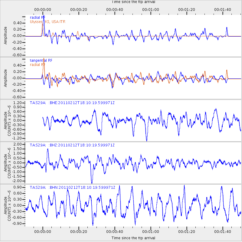
S29A Ulysses, KS, USA - Earthquake Result Viewer
*The percent match for this event was below the threshold and hence no stack was calculated.
| Earthquake location: |
Tonga Islands |
| Earthquake latitude/longitude: |
-20.9/-175.7 |
| Earthquake time(UTC): |
2011/02/12 (043) 17:57:56 GMT |
| Earthquake Depth: |
90 km |
| Earthquake Magnitude: |
6.0 MB, 6.1 MW, 6.1 MW |
| Earthquake Catalog/Contributor: |
WHDF/NEIC |
|
| Network: |
TA USArray Transportable Network (new EarthScope stations) |
| Station: |
S29A Ulysses, KS, USA |
| Lat/Lon: |
37.62 N/101.12 W |
| Elevation: |
931 m |
|
| Distance: |
91.0 deg |
| Az: |
49.951 deg |
| Baz: |
244.35 deg |
| Ray Param: |
$rayparam |
*The percent match for this event was below the threshold and hence was not used in the summary stack. |
|
| Radial Match: |
62.35091 % |
| Radial Bump: |
400 |
| Transverse Match: |
65.197174 % |
| Transverse Bump: |
400 |
| SOD ConfigId: |
350818 |
| Insert Time: |
2011-07-26 08:13:09.569 +0000 |
| GWidth: |
2.5 |
| Max Bumps: |
400 |
| Tol: |
0.001 |
|
Signal To Noise
| Channel | StoN | STA | LTA |
| TA:S29A: :BHZ:20110212T18:10:19.599971Z | 2.2482772 | 6.3482975E-7 | 2.8236275E-7 |
| TA:S29A: :BHN:20110212T18:10:19.599971Z | 1.1752565 | 3.3701838E-7 | 2.8676155E-7 |
| TA:S29A: :BHE:20110212T18:10:19.599971Z | 2.6678612 | 5.6279214E-7 | 2.1095255E-7 |
| Arrivals |
| Ps | |
| PpPs | |
| PsPs/PpSs | |


