You are here: Home > Network List > TA - USArray Transportable Network (new EarthScope stations) Stations List
> Station G25A Newell, SD, USA > Earthquake Result Viewer
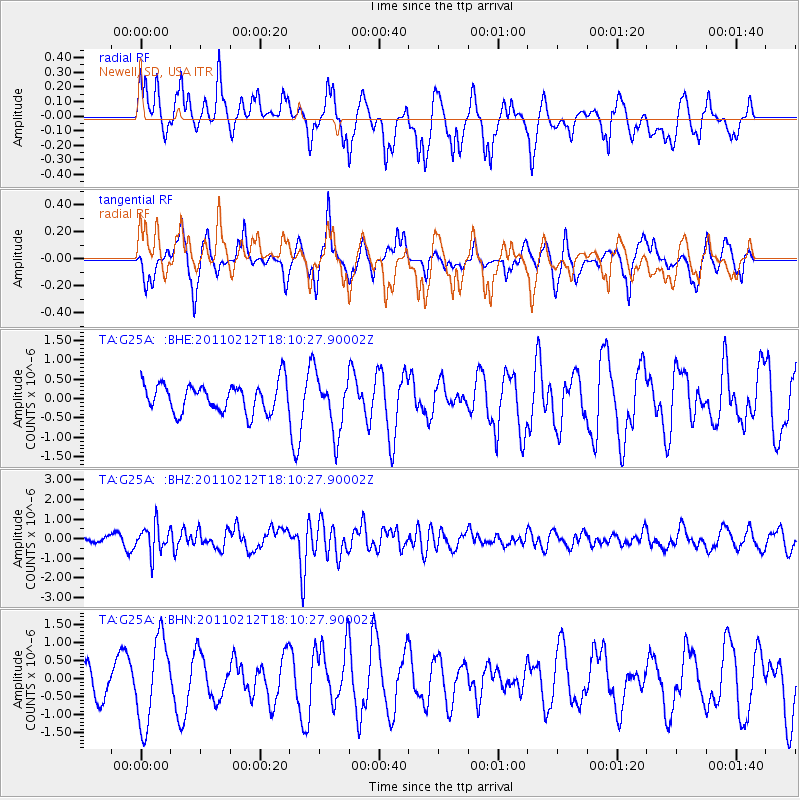
G25A Newell, SD, USA - Earthquake Result Viewer
*The percent match for this event was below the threshold and hence no stack was calculated.
| Earthquake location: |
Tonga Islands |
| Earthquake latitude/longitude: |
-20.9/-175.7 |
| Earthquake time(UTC): |
2011/02/12 (043) 17:57:56 GMT |
| Earthquake Depth: |
90 km |
| Earthquake Magnitude: |
6.0 MB, 6.1 MW, 6.1 MW |
| Earthquake Catalog/Contributor: |
WHDF/NEIC |
|
| Network: |
TA USArray Transportable Network (new EarthScope stations) |
| Station: |
G25A Newell, SD, USA |
| Lat/Lon: |
45.19 N/103.42 W |
| Elevation: |
894 m |
|
| Distance: |
92.8 deg |
| Az: |
42.397 deg |
| Baz: |
243.085 deg |
| Ray Param: |
$rayparam |
*The percent match for this event was below the threshold and hence was not used in the summary stack. |
|
| Radial Match: |
50.495216 % |
| Radial Bump: |
369 |
| Transverse Match: |
47.294094 % |
| Transverse Bump: |
285 |
| SOD ConfigId: |
350818 |
| Insert Time: |
2011-07-26 08:22:10.434 +0000 |
| GWidth: |
2.5 |
| Max Bumps: |
400 |
| Tol: |
0.001 |
|
Signal To Noise
| Channel | StoN | STA | LTA |
| TA:G25A: :BHZ:20110212T18:10:27.90002Z | 3.9935699 | 7.1939337E-7 | 1.8013792E-7 |
| TA:G25A: :BHN:20110212T18:10:27.90002Z | 2.2699268 | 1.1793484E-6 | 5.195535E-7 |
| TA:G25A: :BHE:20110212T18:10:27.90002Z | 1.9676106 | 7.307113E-7 | 3.7136985E-7 |
| Arrivals |
| Ps | |
| PpPs | |
| PsPs/PpSs | |


