You are here: Home > Network List > TA - USArray Transportable Network (new EarthScope stations) Stations List
> Station J05D Fort Rock, OR, USA > Earthquake Result Viewer
J05D Fort Rock, OR, USA - Earthquake Result Viewer
*The percent match for this event was below the threshold and hence no stack was calculated.
| Earthquake location: |
Tonga Islands |
| Earthquake latitude/longitude: |
-20.9/-175.7 |
| Earthquake time(UTC): |
2011/02/12 (043) 17:57:56 GMT |
| Earthquake Depth: |
90 km |
| Earthquake Magnitude: |
6.0 MB, 6.1 MW, 6.1 MW |
| Earthquake Catalog/Contributor: |
WHDF/NEIC |
|
| Network: |
TA USArray Transportable Network (new EarthScope stations) |
| Station: |
J05D Fort Rock, OR, USA |
| Lat/Lon: |
43.28 N/121.23 W |
| Elevation: |
1541 m |
|
| Distance: |
81.1 deg |
| Az: |
36.964 deg |
| Baz: |
230.353 deg |
| Ray Param: |
$rayparam |
*The percent match for this event was below the threshold and hence was not used in the summary stack. |
|
| Radial Match: |
54.1582 % |
| Radial Bump: |
400 |
| Transverse Match: |
56.406986 % |
| Transverse Bump: |
400 |
| SOD ConfigId: |
350818 |
| Insert Time: |
2011-07-26 08:29:11.445 +0000 |
| GWidth: |
2.5 |
| Max Bumps: |
400 |
| Tol: |
0.001 |
|
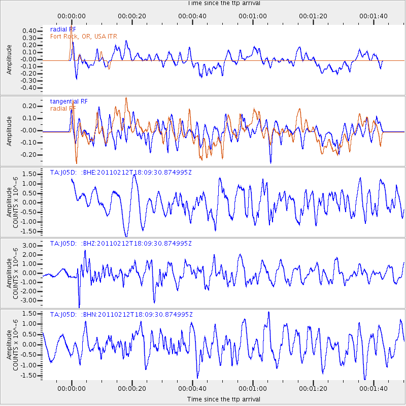
Signal To Noise
| Channel | StoN | STA | LTA |
| TA:J05D: :BHZ:20110212T18:09:30.874995Z | 2.7557569 | 1.2554624E-6 | 4.5557806E-7 |
| TA:J05D: :BHN:20110212T18:09:30.874995Z | 1.2634542 | 5.432002E-7 | 4.299326E-7 |
| TA:J05D: :BHE:20110212T18:09:30.874995Z | 0.53577346 | 4.1014562E-7 | 7.6552055E-7 |
| Arrivals |
| Ps | |
| PpPs | |
| PsPs/PpSs | |


