You are here: Home > Network List > TA - USArray Transportable Network (new EarthScope stations) Stations List
> Station W32A Sentinel, OK, USA > Earthquake Result Viewer
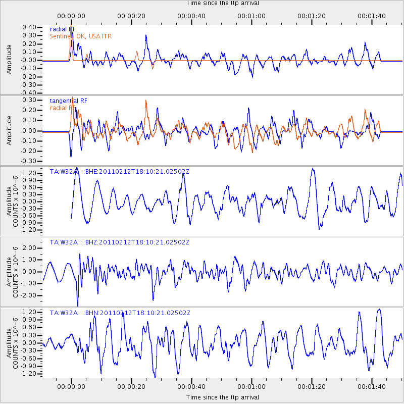
W32A Sentinel, OK, USA - Earthquake Result Viewer
*The percent match for this event was below the threshold and hence no stack was calculated.
| Earthquake location: |
Tonga Islands |
| Earthquake latitude/longitude: |
-20.9/-175.7 |
| Earthquake time(UTC): |
2011/02/12 (043) 17:57:56 GMT |
| Earthquake Depth: |
90 km |
| Earthquake Magnitude: |
6.0 MB, 6.1 MW, 6.1 MW |
| Earthquake Catalog/Contributor: |
WHDF/NEIC |
|
| Network: |
TA USArray Transportable Network (new EarthScope stations) |
| Station: |
W32A Sentinel, OK, USA |
| Lat/Lon: |
35.12 N/99.25 W |
| Elevation: |
494 m |
|
| Distance: |
91.3 deg |
| Az: |
52.849 deg |
| Baz: |
245.397 deg |
| Ray Param: |
$rayparam |
*The percent match for this event was below the threshold and hence was not used in the summary stack. |
|
| Radial Match: |
52.723484 % |
| Radial Bump: |
400 |
| Transverse Match: |
69.85934 % |
| Transverse Bump: |
400 |
| SOD ConfigId: |
350818 |
| Insert Time: |
2011-07-26 08:31:19.429 +0000 |
| GWidth: |
2.5 |
| Max Bumps: |
400 |
| Tol: |
0.001 |
|
Signal To Noise
| Channel | StoN | STA | LTA |
| TA:W32A: :BHZ:20110212T18:10:21.02502Z | 2.2599323 | 9.943184E-7 | 4.3997707E-7 |
| TA:W32A: :BHN:20110212T18:10:21.02502Z | 0.9089308 | 3.1905697E-7 | 3.5102448E-7 |
| TA:W32A: :BHE:20110212T18:10:21.02502Z | 0.81932896 | 4.3494333E-7 | 5.3085313E-7 |
| Arrivals |
| Ps | |
| PpPs | |
| PsPs/PpSs | |


