You are here: Home > Network List > TA - USArray Transportable Network (new EarthScope stations) Stations List
> Station 335A Moody, TX, USA > Earthquake Result Viewer
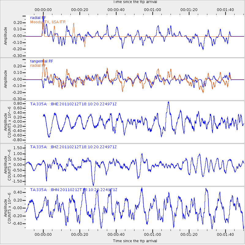
335A Moody, TX, USA - Earthquake Result Viewer
*The percent match for this event was below the threshold and hence no stack was calculated.
| Earthquake location: |
Tonga Islands |
| Earthquake latitude/longitude: |
-20.9/-175.7 |
| Earthquake time(UTC): |
2011/02/12 (043) 17:57:56 GMT |
| Earthquake Depth: |
90 km |
| Earthquake Magnitude: |
6.0 MB, 6.1 MW, 6.1 MW |
| Earthquake Catalog/Contributor: |
WHDF/NEIC |
|
| Network: |
TA USArray Transportable Network (new EarthScope stations) |
| Station: |
335A Moody, TX, USA |
| Lat/Lon: |
31.28 N/97.43 W |
| Elevation: |
217 m |
|
| Distance: |
91.1 deg |
| Az: |
56.969 deg |
| Baz: |
246.3 deg |
| Ray Param: |
$rayparam |
*The percent match for this event was below the threshold and hence was not used in the summary stack. |
|
| Radial Match: |
57.463108 % |
| Radial Bump: |
400 |
| Transverse Match: |
42.99436 % |
| Transverse Bump: |
400 |
| SOD ConfigId: |
350818 |
| Insert Time: |
2011-07-26 08:37:27.870 +0000 |
| GWidth: |
2.5 |
| Max Bumps: |
400 |
| Tol: |
0.001 |
|
Signal To Noise
| Channel | StoN | STA | LTA |
| TA:335A: :BHZ:20110212T18:10:20.224971Z | 1.9591509 | 4.3709835E-7 | 2.2310603E-7 |
| TA:335A: :BHN:20110212T18:10:20.224971Z | 0.91908514 | 1.8918486E-7 | 2.0584041E-7 |
| TA:335A: :BHE:20110212T18:10:20.224971Z | 0.57693917 | 1.537047E-7 | 2.6641405E-7 |
| Arrivals |
| Ps | |
| PpPs | |
| PsPs/PpSs | |


