You are here: Home > Network List > TA - USArray Transportable Network (new EarthScope stations) Stations List
> Station 234A Clairette, TX, USA > Earthquake Result Viewer
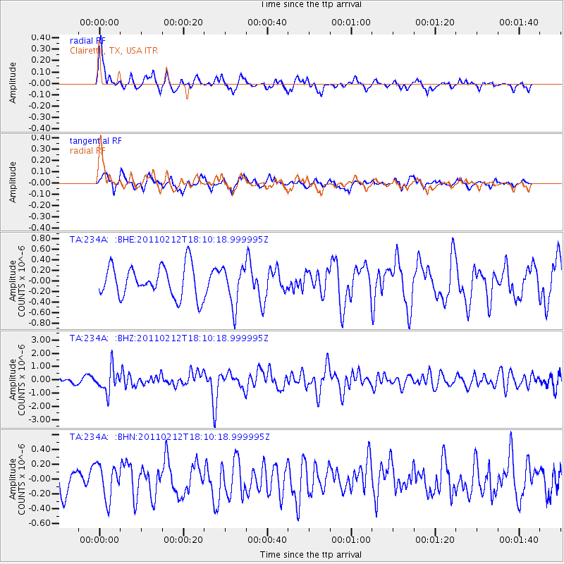
234A Clairette, TX, USA - Earthquake Result Viewer
*The percent match for this event was below the threshold and hence no stack was calculated.
| Earthquake location: |
Tonga Islands |
| Earthquake latitude/longitude: |
-20.9/-175.7 |
| Earthquake time(UTC): |
2011/02/12 (043) 17:57:56 GMT |
| Earthquake Depth: |
90 km |
| Earthquake Magnitude: |
6.0 MB, 6.1 MW, 6.1 MW |
| Earthquake Catalog/Contributor: |
WHDF/NEIC |
|
| Network: |
TA USArray Transportable Network (new EarthScope stations) |
| Station: |
234A Clairette, TX, USA |
| Lat/Lon: |
32.00 N/98.14 W |
| Elevation: |
358 m |
|
| Distance: |
90.9 deg |
| Az: |
56.066 deg |
| Baz: |
245.945 deg |
| Ray Param: |
$rayparam |
*The percent match for this event was below the threshold and hence was not used in the summary stack. |
|
| Radial Match: |
72.86876 % |
| Radial Bump: |
400 |
| Transverse Match: |
40.901295 % |
| Transverse Bump: |
400 |
| SOD ConfigId: |
350818 |
| Insert Time: |
2011-07-26 08:38:10.938 +0000 |
| GWidth: |
2.5 |
| Max Bumps: |
400 |
| Tol: |
0.001 |
|
Signal To Noise
| Channel | StoN | STA | LTA |
| TA:234A: :BHZ:20110212T18:10:18.999995Z | 3.2718055 | 9.238146E-7 | 2.823562E-7 |
| TA:234A: :BHN:20110212T18:10:18.999995Z | 0.7054318 | 2.3123802E-7 | 3.277964E-7 |
| TA:234A: :BHE:20110212T18:10:18.999995Z | 1.2595019 | 3.7364623E-7 | 2.966619E-7 |
| Arrivals |
| Ps | |
| PpPs | |
| PsPs/PpSs | |


