You are here: Home > Network List > TA - USArray Transportable Network (new EarthScope stations) Stations List
> Station Z39A Irene McRaven, Queen City, TX, USA > Earthquake Result Viewer
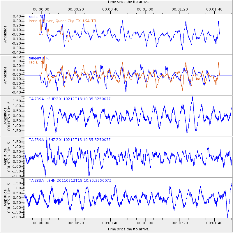
Z39A Irene McRaven, Queen City, TX, USA - Earthquake Result Viewer
*The percent match for this event was below the threshold and hence no stack was calculated.
| Earthquake location: |
Tonga Islands |
| Earthquake latitude/longitude: |
-20.9/-175.7 |
| Earthquake time(UTC): |
2011/02/12 (043) 17:57:56 GMT |
| Earthquake Depth: |
90 km |
| Earthquake Magnitude: |
6.0 MB, 6.1 MW, 6.1 MW |
| Earthquake Catalog/Contributor: |
WHDF/NEIC |
|
| Network: |
TA USArray Transportable Network (new EarthScope stations) |
| Station: |
Z39A Irene McRaven, Queen City, TX, USA |
| Lat/Lon: |
33.24 N/94.18 W |
| Elevation: |
112 m |
|
| Distance: |
94.4 deg |
| Az: |
56.234 deg |
| Baz: |
248.06 deg |
| Ray Param: |
$rayparam |
*The percent match for this event was below the threshold and hence was not used in the summary stack. |
|
| Radial Match: |
63.060905 % |
| Radial Bump: |
400 |
| Transverse Match: |
53.994534 % |
| Transverse Bump: |
384 |
| SOD ConfigId: |
350818 |
| Insert Time: |
2011-07-26 08:53:37.495 +0000 |
| GWidth: |
2.5 |
| Max Bumps: |
400 |
| Tol: |
0.001 |
|
Signal To Noise
| Channel | StoN | STA | LTA |
| TA:Z39A: :BHZ:20110212T18:10:35.325007Z | 2.3478198 | 9.061908E-7 | 3.859712E-7 |
| TA:Z39A: :BHN:20110212T18:10:35.325007Z | 1.0886751 | 5.765126E-7 | 5.295543E-7 |
| TA:Z39A: :BHE:20110212T18:10:35.325007Z | 0.8410546 | 5.216467E-7 | 6.202293E-7 |
| Arrivals |
| Ps | |
| PpPs | |
| PsPs/PpSs | |


