You are here: Home > Network List > TA - USArray Transportable Network (new EarthScope stations) Stations List
> Station L32A Elgin, NE, USA > Earthquake Result Viewer
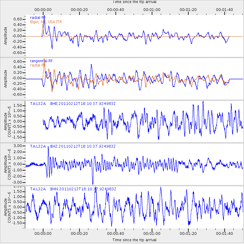
L32A Elgin, NE, USA - Earthquake Result Viewer
*The percent match for this event was below the threshold and hence no stack was calculated.
| Earthquake location: |
Tonga Islands |
| Earthquake latitude/longitude: |
-20.9/-175.7 |
| Earthquake time(UTC): |
2011/02/12 (043) 17:57:56 GMT |
| Earthquake Depth: |
90 km |
| Earthquake Magnitude: |
6.0 MB, 6.1 MW, 6.1 MW |
| Earthquake Catalog/Contributor: |
WHDF/NEIC |
|
| Network: |
TA USArray Transportable Network (new EarthScope stations) |
| Station: |
L32A Elgin, NE, USA |
| Lat/Lon: |
42.00 N/98.01 W |
| Elevation: |
586 m |
|
| Distance: |
95.0 deg |
| Az: |
46.963 deg |
| Baz: |
246.493 deg |
| Ray Param: |
$rayparam |
*The percent match for this event was below the threshold and hence was not used in the summary stack. |
|
| Radial Match: |
67.81262 % |
| Radial Bump: |
400 |
| Transverse Match: |
53.42711 % |
| Transverse Bump: |
400 |
| SOD ConfigId: |
350818 |
| Insert Time: |
2011-07-26 08:58:57.621 +0000 |
| GWidth: |
2.5 |
| Max Bumps: |
400 |
| Tol: |
0.001 |
|
Signal To Noise
| Channel | StoN | STA | LTA |
| TA:L32A: :BHZ:20110212T18:10:37.924983Z | 4.890982 | 1.1009299E-6 | 2.2509383E-7 |
| TA:L32A: :BHN:20110212T18:10:37.924983Z | 1.1240872 | 6.007854E-7 | 5.344652E-7 |
| TA:L32A: :BHE:20110212T18:10:37.924983Z | 1.4046915 | 5.263427E-7 | 3.7470346E-7 |
| Arrivals |
| Ps | |
| PpPs | |
| PsPs/PpSs | |


