You are here: Home > Network List > UW - Pacific Northwest Regional Seismic Network Stations List
> Station HOOD Mt Hood Meadows, OR CREST BB SMO > Earthquake Result Viewer
HOOD Mt Hood Meadows, OR CREST BB SMO - Earthquake Result Viewer
*The percent match for this event was below the threshold and hence no stack was calculated.
| Earthquake location: |
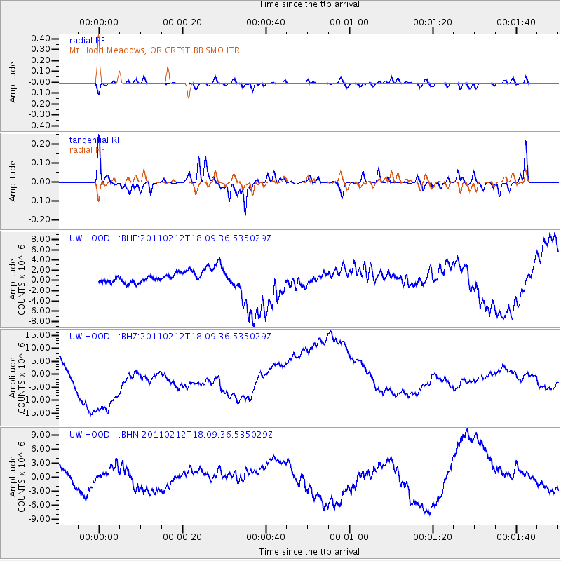
Tonga Islands |
| Earthquake latitude/longitude: |
-20.9/-175.7 |
| Earthquake time(UTC): |
2011/02/12 (043) 17:57:56 GMT |
| Earthquake Depth: |
90 km |
| Earthquake Magnitude: |
6.0 MB, 6.1 MW, 6.1 MW |
| Earthquake Catalog/Contributor: |
WHDF/NEIC |
|
| Network: |
UW Pacific Northwest Regional Seismic Network |
| Station: |
HOOD Mt Hood Meadows, OR CREST BB SMO |
| Lat/Lon: |
45.32 N/121.65 W |
| Elevation: |
1520 m |
|
| Distance: |
82.2 deg |
| Az: |
35.191 deg |
| Baz: |
229.803 deg |
| Ray Param: |
$rayparam |
*The percent match for this event was below the threshold and hence was not used in the summary stack. |
|
| Radial Match: |
53.457825 % |
| Radial Bump: |
367 |
| Transverse Match: |
46.84457 % |
| Transverse Bump: |
238 |
| SOD ConfigId: |
350818 |
| Insert Time: |
2011-07-26 09:17:00.623 +0000 |
| GWidth: |
2.5 |
| Max Bumps: |
400 |
| Tol: |
0.001 |
|
Signal To Noise
| Channel | StoN | STA | LTA |
| UW:HOOD: :BHZ:20110212T18:09:36.535029Z | 2.2404742 | 2.4360164E-5 | 1.0872771E-5 |
| UW:HOOD: :BHN:20110212T18:09:36.535029Z | 0.5465633 | 1.7020359E-6 | 3.114069E-6 |
| UW:HOOD: :BHE:20110212T18:09:36.535029Z | 2.731404 | 2.324958E-6 | 8.5119507E-7 |
| Arrivals |
| Ps | |
| PpPs | |
| PsPs/PpSs | |


