You are here: Home > Network List > UW - Pacific Northwest Regional Seismic Network Stations List
> Station YACT Amboy, WA, USA > Earthquake Result Viewer
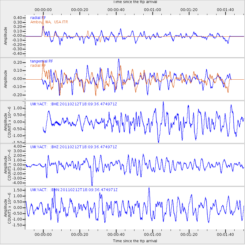
YACT Amboy, WA, USA - Earthquake Result Viewer
*The percent match for this event was below the threshold and hence no stack was calculated.
| Earthquake location: |
Tonga Islands |
| Earthquake latitude/longitude: |
-20.9/-175.7 |
| Earthquake time(UTC): |
2011/02/12 (043) 17:57:56 GMT |
| Earthquake Depth: |
90 km |
| Earthquake Magnitude: |
6.0 MB, 6.1 MW, 6.1 MW |
| Earthquake Catalog/Contributor: |
WHDF/NEIC |
|
| Network: |
UW Pacific Northwest Regional Seismic Network |
| Station: |
YACT Amboy, WA, USA |
| Lat/Lon: |
45.93 N/122.42 W |
| Elevation: |
211 m |
|
| Distance: |
82.1 deg |
| Az: |
34.369 deg |
| Baz: |
229.145 deg |
| Ray Param: |
$rayparam |
*The percent match for this event was below the threshold and hence was not used in the summary stack. |
|
| Radial Match: |
53.419704 % |
| Radial Bump: |
400 |
| Transverse Match: |
67.74109 % |
| Transverse Bump: |
400 |
| SOD ConfigId: |
350818 |
| Insert Time: |
2011-07-26 09:17:28.547 +0000 |
| GWidth: |
2.5 |
| Max Bumps: |
400 |
| Tol: |
0.001 |
|
Signal To Noise
| Channel | StoN | STA | LTA |
| UW:YACT: :BHZ:20110212T18:09:36.474971Z | 3.2939425 | 1.0299748E-6 | 3.1268758E-7 |
| UW:YACT: :BHN:20110212T18:09:36.474971Z | 1.1398127 | 4.0317244E-7 | 3.5371815E-7 |
| UW:YACT: :BHE:20110212T18:09:36.474971Z | 0.5382141 | 1.6934285E-7 | 3.1463844E-7 |
| Arrivals |
| Ps | |
| PpPs | |
| PsPs/PpSs | |


