You are here: Home > Network List > XG92 - Rocky Mountain Front Stations List
> Station MGP near Dinosaur, CO > Earthquake Result Viewer
MGP near Dinosaur, CO - Earthquake Result Viewer
| Earthquake location: |
Southeast Of Honshu, Japan |
| Earthquake latitude/longitude: |
32.5/141.7 |
| Earthquake time(UTC): |
1992/08/11 (224) 15:14:56 GMT |
| Earthquake Depth: |
28 km |
| Earthquake Magnitude: |
5.8 MB, 6.2 MS |
| Earthquake Catalog/Contributor: |
WHDF/NEIC |
|
| Network: |
XG Rocky Mountain Front |
| Station: |
MGP near Dinosaur, CO |
| Lat/Lon: |
40.26 N/108.78 W |
| Elevation: |
1811 m |
|
| Distance: |
82.6 deg |
| Az: |
46.659 deg |
| Baz: |
306.606 deg |
| Ray Param: |
0.046731163 |
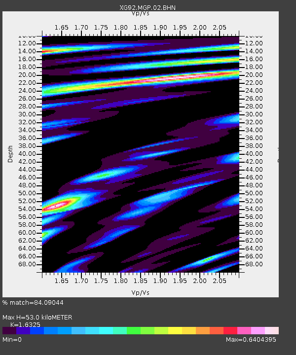
| Estimated Moho Depth: |
53.0 km |
| Estimated Crust Vp/Vs: |
1.63 |
| Assumed Crust Vp: |
6.207 km/s |
| Estimated Crust Vs: |
3.802 km/s |
| Estimated Crust Poisson's Ratio: |
0.20 |
|
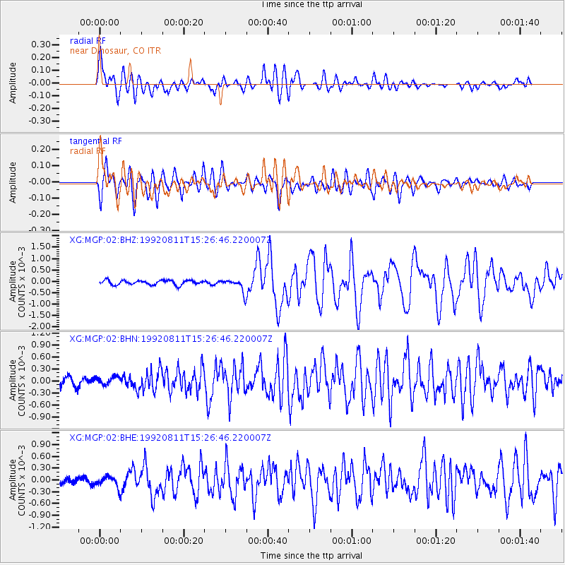
| Radial Match: |
84.09044 % |
| Radial Bump: |
400 |
| Transverse Match: |
82.281265 % |
| Transverse Bump: |
400 |
| SOD ConfigId: |
3286 |
| Insert Time: |
2010-02-25 20:10:15.655 +0000 |
| GWidth: |
2.5 |
| Max Bumps: |
400 |
| Tol: |
0.001 |
|
Signal To Noise
| Channel | StoN | STA | LTA |
| XG:MGP:02:BHN:19920811T15:26:46.220007Z | 0.9417661 | 9.777933E-5 | 1.038255E-4 |
| XG:MGP:02:BHE:19920811T15:26:46.220007Z | 1.5333846 | 1.3976025E-4 | 9.114494E-5 |
| XG:MGP:02:BHZ:19920811T15:26:46.220007Z | 3.1139412 | 3.0769766E-4 | 9.8812925E-5 |
| Arrivals |
| Ps | 5.5 SECOND |
| PpPs | 22 SECOND |
| PsPs/PpSs | 27 SECOND |


