You are here: Home > Network List > TA - USArray Transportable Network (new EarthScope stations) Stations List
> Station A33A Warroad, MN, USA > Earthquake Result Viewer
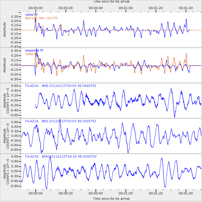
A33A Warroad, MN, USA - Earthquake Result Viewer
*The percent match for this event was below the threshold and hence no stack was calculated.
| Earthquake location: |
Near Coast Of Central Chile |
| Earthquake latitude/longitude: |
-36.6/-73.2 |
| Earthquake time(UTC): |
2011/02/13 (044) 08:51:34 GMT |
| Earthquake Depth: |
21 km |
| Earthquake Magnitude: |
5.7 MS, 5.4 MB, 5.9 MW, 5.8 MW |
| Earthquake Catalog/Contributor: |
WHDF/NEIC |
|
| Network: |
TA USArray Transportable Network (new EarthScope stations) |
| Station: |
A33A Warroad, MN, USA |
| Lat/Lon: |
48.94 N/95.39 W |
| Elevation: |
329 m |
|
| Distance: |
87.4 deg |
| Az: |
345.55 deg |
| Baz: |
162.261 deg |
| Ray Param: |
$rayparam |
*The percent match for this event was below the threshold and hence was not used in the summary stack. |
|
| Radial Match: |
43.25446 % |
| Radial Bump: |
359 |
| Transverse Match: |
56.936317 % |
| Transverse Bump: |
400 |
| SOD ConfigId: |
350818 |
| Insert Time: |
2011-07-26 09:52:42.292 +0000 |
| GWidth: |
2.5 |
| Max Bumps: |
400 |
| Tol: |
0.001 |
|
Signal To Noise
| Channel | StoN | STA | LTA |
| TA:A33A: :BHZ:20110213T09:03:48.099976Z | 2.4853432 | 6.572285E-7 | 2.6444175E-7 |
| TA:A33A: :BHN:20110213T09:03:48.099976Z | 0.9960429 | 3.8803813E-7 | 3.8957975E-7 |
| TA:A33A: :BHE:20110213T09:03:48.099976Z | 1.0860705 | 2.0113563E-7 | 1.8519573E-7 |
| Arrivals |
| Ps | |
| PpPs | |
| PsPs/PpSs | |


