You are here: Home > Network List > AV - Alaska Volcano Observatory Stations List
> Station SPCR Ckakachatna River, Mount Spurr, Alaska > Earthquake Result Viewer
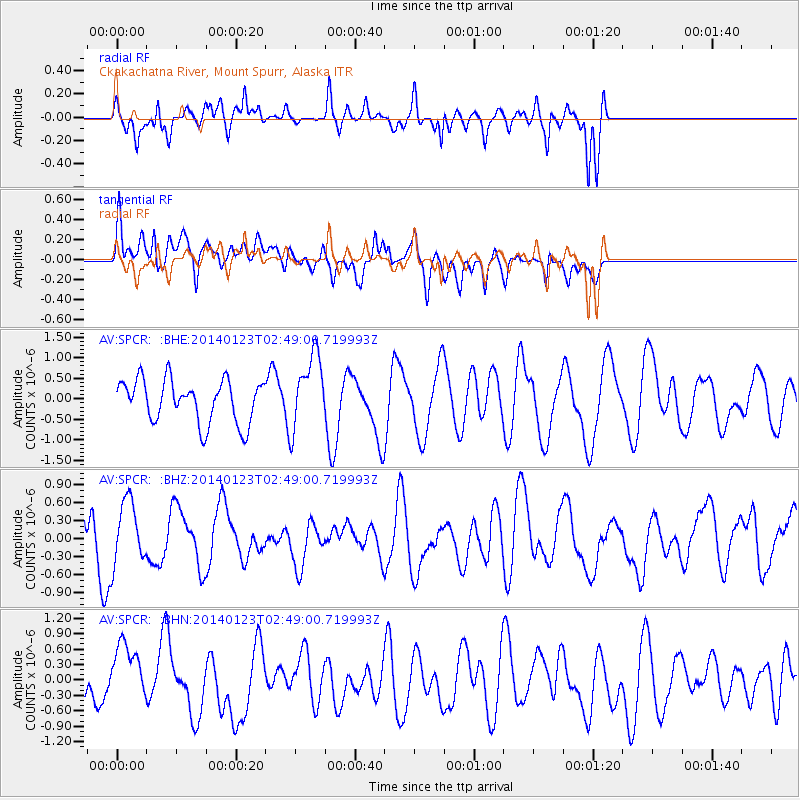
SPCR Ckakachatna River, Mount Spurr, Alaska - Earthquake Result Viewer
*The percent match for this event was below the threshold and hence no stack was calculated.
| Earthquake location: |
Banda Sea |
| Earthquake latitude/longitude: |
-7.8/129.3 |
| Earthquake time(UTC): |
2014/01/23 (023) 02:36:30 GMT |
| Earthquake Depth: |
35 km |
| Earthquake Magnitude: |
5.2 MW |
| Earthquake Catalog/Contributor: |
ISC/ISC |
|
| Network: |
AV Alaska Volcano Observatory |
| Station: |
SPCR Ckakachatna River, Mount Spurr, Alaska |
| Lat/Lon: |
61.20 N/152.21 W |
| Elevation: |
984 m |
|
| Distance: |
91.3 deg |
| Az: |
28.334 deg |
| Baz: |
256.216 deg |
| Ray Param: |
$rayparam |
*The percent match for this event was below the threshold and hence was not used in the summary stack. |
|
| Radial Match: |
49.4086 % |
| Radial Bump: |
301 |
| Transverse Match: |
48.22212 % |
| Transverse Bump: |
400 |
| SOD ConfigId: |
3390531 |
| Insert Time: |
2019-04-10 02:06:37.039 +0000 |
| GWidth: |
2.5 |
| Max Bumps: |
400 |
| Tol: |
0.001 |
|
Signal To Noise
| Channel | StoN | STA | LTA |
| AV:SPCR: :BHZ:20140123T02:49:00.719993Z | 1.5408914 | 5.314432E-7 | 3.4489338E-7 |
| AV:SPCR: :BHN:20140123T02:49:00.719993Z | 1.6241547 | 5.744773E-7 | 3.5370851E-7 |
| AV:SPCR: :BHE:20140123T02:49:00.719993Z | 1.7630838 | 9.157875E-7 | 5.194237E-7 |
| Arrivals |
| Ps | |
| PpPs | |
| PsPs/PpSs | |


