You are here: Home > Network List > LD - Lamont-Doherty Cooperative Seismographic Network Stations List
> Station MVL Millersville University, PA > Earthquake Result Viewer
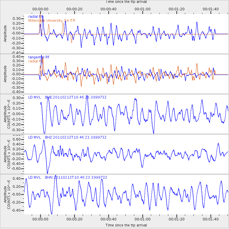
MVL Millersville University, PA - Earthquake Result Viewer
*The percent match for this event was below the threshold and hence no stack was calculated.
| Earthquake location: |
Near Coast Of Central Chile |
| Earthquake latitude/longitude: |
-36.6/-73.2 |
| Earthquake time(UTC): |
2011/02/13 (044) 10:35:06 GMT |
| Earthquake Depth: |
17 km |
| Earthquake Magnitude: |
5.6 MB, 5.8 MS, 6.0 MW, 6.0 MW |
| Earthquake Catalog/Contributor: |
WHDF/NEIC |
|
| Network: |
LD Lamont-Doherty Cooperative Seismographic Network |
| Station: |
MVL Millersville University, PA |
| Lat/Lon: |
40.00 N/76.35 W |
| Elevation: |
91 m |
|
| Distance: |
76.3 deg |
| Az: |
357.491 deg |
| Baz: |
177.373 deg |
| Ray Param: |
$rayparam |
*The percent match for this event was below the threshold and hence was not used in the summary stack. |
|
| Radial Match: |
51.23389 % |
| Radial Bump: |
368 |
| Transverse Match: |
57.82866 % |
| Transverse Bump: |
400 |
| SOD ConfigId: |
350818 |
| Insert Time: |
2011-07-26 10:15:59.236 +0000 |
| GWidth: |
2.5 |
| Max Bumps: |
400 |
| Tol: |
0.001 |
|
Signal To Noise
| Channel | StoN | STA | LTA |
| LD:MVL: :BHZ:20110213T10:46:23.399973Z | 2.7684739 | 4.0030912E-7 | 1.4459559E-7 |
| LD:MVL: :BHN:20110213T10:46:23.399973Z | 0.41638574 | 8.156624E-8 | 1.9589105E-7 |
| LD:MVL: :BHE:20110213T10:46:23.399973Z | 0.8068396 | 1.1888896E-7 | 1.4735143E-7 |
| Arrivals |
| Ps | |
| PpPs | |
| PsPs/PpSs | |


