You are here: Home > Network List > TA - USArray Transportable Network (new EarthScope stations) Stations List
> Station F29A Eureka, SD, USA > Earthquake Result Viewer
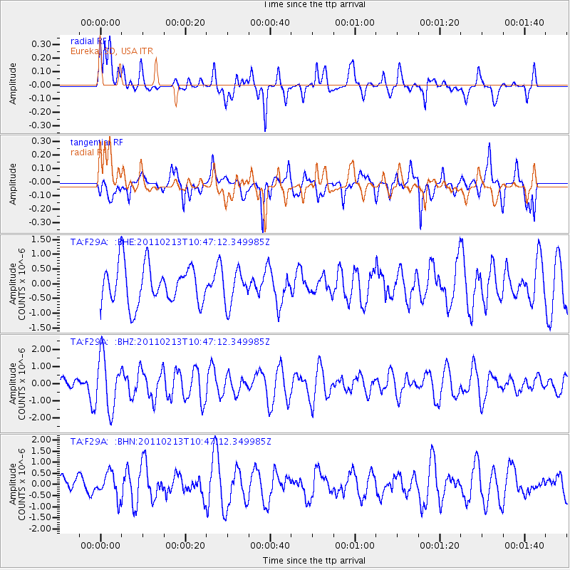
F29A Eureka, SD, USA - Earthquake Result Viewer
*The percent match for this event was below the threshold and hence no stack was calculated.
| Earthquake location: |
Near Coast Of Central Chile |
| Earthquake latitude/longitude: |
-36.6/-73.2 |
| Earthquake time(UTC): |
2011/02/13 (044) 10:35:06 GMT |
| Earthquake Depth: |
17 km |
| Earthquake Magnitude: |
5.6 MB, 5.8 MS, 6.0 MW, 6.0 MW |
| Earthquake Catalog/Contributor: |
WHDF/NEIC |
|
| Network: |
TA USArray Transportable Network (new EarthScope stations) |
| Station: |
F29A Eureka, SD, USA |
| Lat/Lon: |
45.83 N/99.83 W |
| Elevation: |
575 m |
|
| Distance: |
85.5 deg |
| Az: |
341.666 deg |
| Baz: |
158.787 deg |
| Ray Param: |
$rayparam |
*The percent match for this event was below the threshold and hence was not used in the summary stack. |
|
| Radial Match: |
63.3629 % |
| Radial Bump: |
400 |
| Transverse Match: |
66.057236 % |
| Transverse Bump: |
400 |
| SOD ConfigId: |
350818 |
| Insert Time: |
2011-07-26 10:46:17.212 +0000 |
| GWidth: |
2.5 |
| Max Bumps: |
400 |
| Tol: |
0.001 |
|
Signal To Noise
| Channel | StoN | STA | LTA |
| TA:F29A: :BHZ:20110213T10:47:12.349985Z | 2.7166612 | 1.5533739E-6 | 5.7179517E-7 |
| TA:F29A: :BHN:20110213T10:47:12.349985Z | 1.1698003 | 5.719357E-7 | 4.8891735E-7 |
| TA:F29A: :BHE:20110213T10:47:12.349985Z | 0.8807029 | 5.815853E-7 | 6.6036495E-7 |
| Arrivals |
| Ps | |
| PpPs | |
| PsPs/PpSs | |


