You are here: Home > Network List > AZ - ANZA Regional Network Stations List
> Station KNW AZ.KNW > Earthquake Result Viewer
KNW AZ.KNW - Earthquake Result Viewer
| Earthquake location: |
Central Alaska |
| Earthquake latitude/longitude: |
63.5/-147.4 |
| Earthquake time(UTC): |
2002/11/03 (307) 22:12:41 GMT |
| Earthquake Depth: |
4.9 km |
| Earthquake Magnitude: |
7.0 MB, 8.5 MS, 7.9 MW |
| Earthquake Catalog/Contributor: |
WHDF/NEIC |
|
| Network: |
AZ ANZA Regional Network |
| Station: |
KNW AZ.KNW |
| Lat/Lon: |
33.71 N/116.71 W |
| Elevation: |
1507 m |
|
| Distance: |
35.4 deg |
| Az: |
132.677 deg |
| Baz: |
336.707 deg |
| Ray Param: |
0.07725252 |
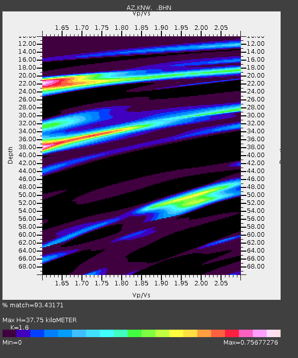
| Estimated Moho Depth: |
37.75 km |
| Estimated Crust Vp/Vs: |
1.60 |
| Assumed Crust Vp: |
6.264 km/s |
| Estimated Crust Vs: |
3.915 km/s |
| Estimated Crust Poisson's Ratio: |
0.18 |
|
| Radial Match: |
93.43171 % |
| Radial Bump: |
235 |
| Transverse Match: |
77.19217 % |
| Transverse Bump: |
400 |
| SOD ConfigId: |
32974 |
| Insert Time: |
2010-02-26 19:29:15.464 +0000 |
| GWidth: |
2.5 |
| Max Bumps: |
400 |
| Tol: |
0.001 |
|
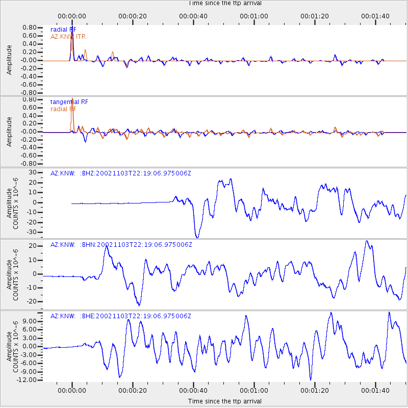
Signal To Noise
| Channel | StoN | STA | LTA |
| AZ:KNW: :BHN:20021103T22:19:06.975006Z | 1.8263993 | 2.1738133E-6 | 1.190218E-6 |
| AZ:KNW: :BHE:20021103T22:19:06.975006Z | 1.0741885 | 4.5965234E-7 | 4.2790657E-7 |
| AZ:KNW: :BHZ:20021103T22:19:06.975006Z | 8.931808 | 2.8453549E-6 | 3.1856425E-7 |
| Arrivals |
| Ps | 3.9 SECOND |
| PpPs | 14 SECOND |
| PsPs/PpSs | 18 SECOND |


