You are here: Home > Network List > AZ - ANZA Regional Network Stations List
> Station KNW AZ.KNW > Earthquake Result Viewer
KNW AZ.KNW - Earthquake Result Viewer

| Earthquake location: |
Fiji Islands Region |
| Earthquake latitude/longitude: |
-21.7/-179.5 |
| Earthquake time(UTC): |
2002/08/19 (231) 11:01:01 GMT |
| Earthquake Depth: |
580 km |
| Earthquake Magnitude: |
6.7 MB, 7.6 MW, 7.7 ME |
| Earthquake Catalog/Contributor: |
WHDF/NEIC |
|
| Network: |
AZ ANZA Regional Network |
| Station: |
KNW AZ.KNW |
| Lat/Lon: |
33.71 N/116.71 W |
| Elevation: |
1507 m |
|
| Distance: |
81.3 deg |
| Az: |
48.59 deg |
| Baz: |
236.804 deg |
| Ray Param: |
0.045925483 |
| Estimated Moho Depth: |
15.25 km |
| Estimated Crust Vp/Vs: |
1.89 |
| Assumed Crust Vp: |
6.264 km/s |
| Estimated Crust Vs: |
3.305 km/s |
| Estimated Crust Poisson's Ratio: |
0.31 |
|
| Radial Match: |
92.88401 % |
| Radial Bump: |
400 |
| Transverse Match: |
78.32218 % |
| Transverse Bump: |
400 |
| SOD ConfigId: |
32974 |
| Insert Time: |
2010-02-26 19:29:17.627 +0000 |
| GWidth: |
2.5 |
| Max Bumps: |
400 |
| Tol: |
0.001 |
|
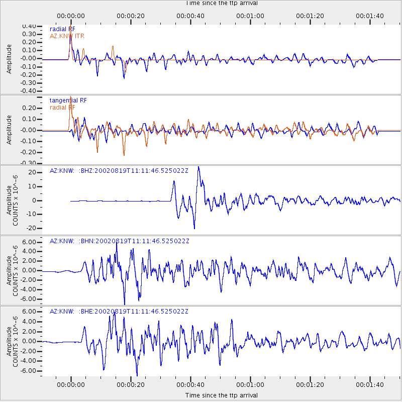
Signal To Noise
| Channel | StoN | STA | LTA |
| AZ:KNW: :BHN:20020819T11:11:46.525022Z | 9.444312 | 6.964046E-7 | 7.3737986E-8 |
| AZ:KNW: :BHE:20020819T11:11:46.525022Z | 14.57055 | 1.0825866E-6 | 7.4299635E-8 |
| AZ:KNW: :BHZ:20020819T11:11:46.525022Z | 50.744644 | 4.8327875E-6 | 9.523739E-8 |
| Arrivals |
| Ps | 2.2 SECOND |
| PpPs | 6.9 SECOND |
| PsPs/PpSs | 9.1 SECOND |


