You are here: Home > Network List > TA - USArray Transportable Network (new EarthScope stations) Stations List
> Station U36A Oologah, OK, USA > Earthquake Result Viewer
U36A Oologah, OK, USA - Earthquake Result Viewer
*The percent match for this event was below the threshold and hence no stack was calculated.
| Earthquake location: |
Near Coast Of Central Chile |
| Earthquake latitude/longitude: |
-36.6/-73.2 |
| Earthquake time(UTC): |
2011/02/13 (044) 10:35:06 GMT |
| Earthquake Depth: |
17 km |
| Earthquake Magnitude: |
5.6 MB, 5.8 MS, 6.0 MW, 6.0 MW |
| Earthquake Catalog/Contributor: |
WHDF/NEIC |
|
| Network: |
TA USArray Transportable Network (new EarthScope stations) |
| Station: |
U36A Oologah, OK, USA |
| Lat/Lon: |
36.39 N/95.73 W |
| Elevation: |
187 m |
|
| Distance: |
75.6 deg |
| Az: |
341.367 deg |
| Baz: |
161.43 deg |
| Ray Param: |
$rayparam |
*The percent match for this event was below the threshold and hence was not used in the summary stack. |
|
| Radial Match: |
46.23212 % |
| Radial Bump: |
400 |
| Transverse Match: |
46.664093 % |
| Transverse Bump: |
400 |
| SOD ConfigId: |
350818 |
| Insert Time: |
2011-07-26 11:43:05.090 +0000 |
| GWidth: |
2.5 |
| Max Bumps: |
400 |
| Tol: |
0.001 |
|
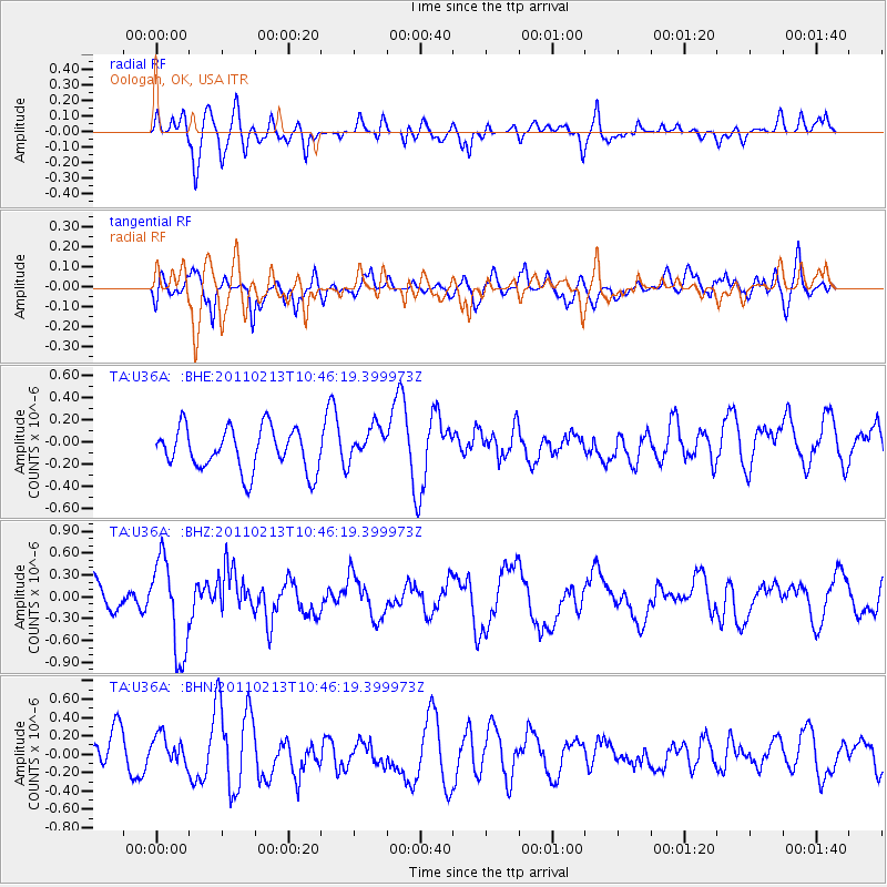
Signal To Noise
| Channel | StoN | STA | LTA |
| TA:U36A: :BHZ:20110213T10:46:19.399973Z | 3.3526423 | 6.3902604E-7 | 1.906037E-7 |
| TA:U36A: :BHN:20110213T10:46:19.399973Z | 0.83999616 | 1.5955492E-7 | 1.8994719E-7 |
| TA:U36A: :BHE:20110213T10:46:19.399973Z | 0.8243977 | 1.5656306E-7 | 1.8991206E-7 |
| Arrivals |
| Ps | |
| PpPs | |
| PsPs/PpSs | |


