You are here: Home > Network List > II - Global Seismograph Network (GSN - IRIS/IDA) Stations List
> Station WRAB Tennant Creek, NT, Australia > Earthquake Result Viewer
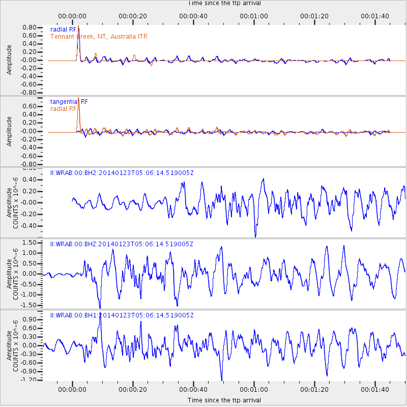
WRAB Tennant Creek, NT, Australia - Earthquake Result Viewer
*The percent match for this event was below the threshold and hence no stack was calculated.
| Earthquake location: |
South Of Mariana Islands |
| Earthquake latitude/longitude: |
13.4/146.1 |
| Earthquake time(UTC): |
2014/01/23 (023) 04:59:49 GMT |
| Earthquake Depth: |
7.0 km |
| Earthquake Magnitude: |
5.8 MWW, 5.8 MWB, 5.8 MWC |
| Earthquake Catalog/Contributor: |
NEIC PDE/NEIC COMCAT |
|
| Network: |
II Global Seismograph Network (GSN - IRIS/IDA) |
| Station: |
WRAB Tennant Creek, NT, Australia |
| Lat/Lon: |
19.93 S/134.36 E |
| Elevation: |
366 m |
|
| Distance: |
35.1 deg |
| Az: |
199.528 deg |
| Baz: |
20.231 deg |
| Ray Param: |
$rayparam |
*The percent match for this event was below the threshold and hence was not used in the summary stack. |
|
| Radial Match: |
88.61647 % |
| Radial Bump: |
303 |
| Transverse Match: |
57.30536 % |
| Transverse Bump: |
400 |
| SOD ConfigId: |
3390531 |
| Insert Time: |
2019-04-10 02:10:45.784 +0000 |
| GWidth: |
2.5 |
| Max Bumps: |
400 |
| Tol: |
0.001 |
|
Signal To Noise
| Channel | StoN | STA | LTA |
| II:WRAB:00:BHZ:20140123T05:06:14.519005Z | 1.1354594 | 1.8950567E-7 | 1.6689779E-7 |
| II:WRAB:00:BH1:20140123T05:06:14.519005Z | 1.4312911 | 1.6831433E-7 | 1.1759615E-7 |
| II:WRAB:00:BH2:20140123T05:06:14.519005Z | 1.2857944 | 8.700967E-8 | 6.766997E-8 |
| Arrivals |
| Ps | |
| PpPs | |
| PsPs/PpSs | |


