You are here: Home > Network List > TA - USArray Transportable Network (new EarthScope stations) Stations List
> Station O38A Galt, MO, USA > Earthquake Result Viewer
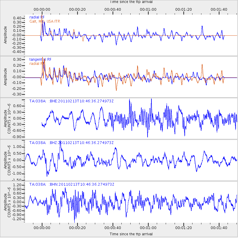
O38A Galt, MO, USA - Earthquake Result Viewer
*The percent match for this event was below the threshold and hence no stack was calculated.
| Earthquake location: |
Near Coast Of Central Chile |
| Earthquake latitude/longitude: |
-36.6/-73.2 |
| Earthquake time(UTC): |
2011/02/13 (044) 10:35:06 GMT |
| Earthquake Depth: |
17 km |
| Earthquake Magnitude: |
5.6 MB, 5.8 MS, 6.0 MW, 6.0 MW |
| Earthquake Catalog/Contributor: |
WHDF/NEIC |
|
| Network: |
TA USArray Transportable Network (new EarthScope stations) |
| Station: |
O38A Galt, MO, USA |
| Lat/Lon: |
40.12 N/93.47 W |
| Elevation: |
266 m |
|
| Distance: |
78.6 deg |
| Az: |
344.258 deg |
| Baz: |
163.468 deg |
| Ray Param: |
$rayparam |
*The percent match for this event was below the threshold and hence was not used in the summary stack. |
|
| Radial Match: |
43.086163 % |
| Radial Bump: |
400 |
| Transverse Match: |
51.92355 % |
| Transverse Bump: |
400 |
| SOD ConfigId: |
350818 |
| Insert Time: |
2011-07-26 12:30:02.319 +0000 |
| GWidth: |
2.5 |
| Max Bumps: |
400 |
| Tol: |
0.001 |
|
Signal To Noise
| Channel | StoN | STA | LTA |
| TA:O38A: :BHZ:20110213T10:46:36.274973Z | 1.9297632 | 5.920454E-7 | 3.0679692E-7 |
| TA:O38A: :BHN:20110213T10:46:36.274973Z | 1.0425823 | 3.009159E-7 | 2.8862559E-7 |
| TA:O38A: :BHE:20110213T10:46:36.274973Z | 1.5822333 | 3.5683277E-7 | 2.2552474E-7 |
| Arrivals |
| Ps | |
| PpPs | |
| PsPs/PpSs | |


